
This item has been sold, but you can enter your email address to be notified if another example becomes available.


|
||

|

|
|

|
Stock# 21988
Description
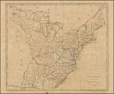
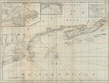
Detailed pair of maps of the British Colonies in North America, based upon John Mitchell's recently published map.
The upper map shows many Indian Tribes named and some early French forts in Illinois and Indiana, indlucing Ft. Sakis, St Francis Xavier Fort, Fort of the Miamis, St Ionace Fort, Fort Pontchetrain, Ft St . Joseph, Ft. Sandoski, le Rocher Fort, and others.
The lower map includes many Indian Tribes, early forts and an English Factory near the Chickasaw nation.
While the map was published in London, its source is an amalgam of French and English data, most notably Bellin's map of the Great Lakes and Mitchell's map of North America.

![A New Map of Virginia [Chesapeake]](https://storage.googleapis.com/raremaps/img/small/43053.jpg)
![(The First Letter From British Florida) [September 5, 1763, Autograph Letter, Signed, from Robert Campbell to John Campbell, 4th Earl of Loudoun, describing the British taking possession of Florida and the state of the settlement of Pensacola]](https://storage.googleapis.com/raremaps/img/small/86620.jpg)