|
||

|

|
|

|
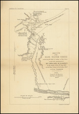
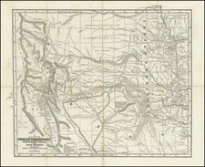
Rare separately issued land agency map, centered on the area between Beach and Richardson North Dakota and centered on the area which would become the Theodore Roosevelt National Park, South Unit.
The map provides a very detailed look at the region, including early roads, post offices, watershed and townships. One of the most noteworthy features are the several subdivided townships, which were likely those available for sale through the Egeland Land Agency. A proposed route for the Chicago, Milwaukee & St. Paul RR is also noted. We located very little information about this company, except for several entries in Polk's Guide to St. Paul in 1906 and 1915.
In 1884, after the death of his wife and mother, Teddie Roosevelt traveled to his North Dakota ranch to escape his personal tragedy. For most of next two years he remained in the area and wrote several pieces published in eastern newspapers and magazines. While he returned east, the experience left a lasting impact on Roosevelt. The National Park was ultimately established on lands which had in part been a part of Roosevelt's ranch. Roosevelt's last n visit to the area was in 1892. He sold the ranch and buildings to Sylvane Ferris in 1898. Gradually the buildings were stripped of their furnishings and, according to a local lore, by 1901 "every scrap of the Elkhorn Ranch had disappeared with the exception of a couple of half rotted foundations."