|
||

|

|
|

|
Extremely rare early (probably the first printed) map of Larkspur, in Marin County, California, "Property of the American Land and Trust Co." and printed by MacCabe & Co. Zinco in San Francisco. One of only two maps attributable to HC Ward of which we are aware (the other being a map of San Luis Obispo).
Remarkable early cadastral map of the town of Larkspur, bounded on the north partly by Mimosa Avenue and partly by the North Pacific Coast Railroad tracks; on the east by Arroyo Estero; on the south by Madrona Avenue; and on the west by Olive and Acacia avenues. Shows streets and lots (with measurements) and the location of existing buildings. Manuscript X's note lots which have apparently been sold, including several names. The names of neighboring land owners are printed on the outskirts of town.
This example bears the handwritten book plate/signature of W.R.H. Adamson. Adamson was part of the firm of Adamson & Moon and one of Adoph Sutro's agents. He served as the Executor of the Adolph Sutro's will, along with Emma Merritt.
Larkspur was laid out by Charles W. Wright in 1887. Its first post office was opened in 1891 and the town incorporated in 1908
OCLC locates only 1 copy of this map, which may be a variant edition, which is listed as "Provenance: American Land and Trust Co. records" and which may no longer exist in its original form. The OCLC entry indicates that the verso included "Promotional text on the advantages of Larkspur real estate prepared by Shainwald, Buckbee & Co." and under Other Titles, noted "Gem of California, Larkspur the home of the redwood and the laurel; Larkspur, the home of the redwood and the laurel; Title from panel:; Read this carefully and consider! The gem of California, Larkspur, the home of the redwood and the laurel.
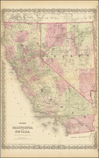
Benjamin P. Ward was an American publisher. He was best known for his partnership with A. J. Johnson. In 1860, the Johnson firm published its first significant work, the Johnson’s New Illustrated (Steel Plate) Family Atlas. The first edition of the Atlas bears imprints in both New York and Richmond, VA. In 1861, however, following the outbreak of the American Civil War, the Johnson & Browning firm abandoned their Richmond location. Browning seems to have remained in Virginia to pursue other ventures and, in 1861, Browning’s portion of the firm was purchased by Ward. The 1863 issue of the Atlas was one of the most unusual, it being a compilation of older Johnson and Browning maps, updated 1862 Johnson and Ward maps, and newer 1863 maps with a revised border design. The 1864 issue of the Atlas is the first true Johnson and Ward atlas. Johnson published one more edition in partnership with Ward in 1865, after which Johnson becomes the sole publisher.
![[Alaska to San Diego and San Qunitin, British Columbia] A Chart Shewing Part of the Coast of N.W. America, with the Tracks of His Majesty's Sloop Discovery and Armed Tender Chatham . . . (First Modern Map of the West Coast of North America)](https://storage.googleapis.com/raremaps/img/small/102067.jpg)

![[Santa Cruz & Santa Clara Counties] Denny's Pocket Map of Santa Cruz County, California. Compiled From the Latest and Official Data . . . `1916](https://storage.googleapis.com/raremaps/img/small/80637.jpg)