|
||

|

|
|

|
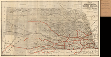
Fascinating map of Nebaska Territory, printed in 1857 and apparently annotated in the Summer of 1866, covering the Dakotas, Kansas, Nebraska and a large part of Colorado, Wyoming and Montana from a scarce Geological report. The map has been extensively annotated by an early owner, whose name appears on the verso.
The map was almost certainly used by a military officer travelling from Kansas City up the Missouri River to Fort Buford, then along the Yellowstone River to the Bozeman area and Virginia City, then on to Salt Lake City, before returned to Kansas City via Fort Bridgerand South Fork (or the opposite direction would also be possible). The route to the Gold Regions from Kansas City to the Denver area is shown.
The map includes some excellent early manuscript notes and was clearly used in the field by an early traveller, quite possibly someone in the party led by Colonel Delos Bennett Sackett, who toured the Forts of the Upper Missouri in May and June of 1866, as part of a greater mission to investigate the various routes to the Gold Region around Virginia City in Montana Territory. The map indeed locates several of the routes to Virginia City then being advocated.
Turning to the manuscript additions to the map, Old Fort Sully (1863-1866) is located, as are Fort Thompson (founded 1863), Fort Rice (1864-1878), Ft Buford (establish June 1866) and a mysterious Fort Sackett (located at the future location of the second Fort Sully), almost certainly named (by the owner of the map) for Colonel Sackett, who was responsible for the directive that Fort Sully be relocated up river to a new location, which was done in May 1866, immediately following Col. Sackett's visit. This strongly suggests that the maker of the map was present during the time the fort was being relocated, as we find no record of the fort ever officially being named for Sackett and we could not locate any record of the name "Fort Sackett" in Dakota Territory being used on a map or otherwise (Fort Sackett is also the name of an early fort in New York).
One of the most fascinating additions is the location of Eagle Rock Bridge, crossing the Snake River just above Idaho Falls. The Eagle Rock Ferry was established in 1863 by Harry Rickard and William Hickman, with the idea of creating a shorter route for Upper Missouri gold miners and westward emigrants. The first crossing occured on June 20, 1863. The Ferry was named for eagles nesting on the rocks above the crossing. In May 1863, General Patrick Conner sent a 45 man detachment from Soda Springs to determine the shortest route to Eagle Rock Ferry. In the Summer of 1864, James Madison Taylor came to the area to construct stage stations for the Salt Lake-Virginia City branch of Ben Holladay's Overland Stage. He chose the Eagle Rock Ferry and purchased the ferry from Rickard and Hickman. Thereafter, Taylor joined with Edgar Morgan and William Bartlett to form the Oneida Road, Bridge and Ferry Company, which received a bridge and ferry franchse from the Territorial Legislature on December 10, 1864. In the Summer of 1865, Taylor completed his bridge, which became one of the most important routes in the region.
The map also notes "Boseman Cy" and Virginia City. Because the map's annotations are in a combination of pencil and two different inks, it may reasonably be surmised that the manuscript is either the work of more than one person or a field map used over an extended period of time by a military officer travelling through the region. Link to verso name here: www.raremaps.com/gallery/enlarge/21868a
![[First Map of the Mississippi River] Carte de la decouverte faite l'an dans l'Amerique Septentrionale](https://storage.googleapis.com/raremaps/img/small/93571.jpg)