


|
||

|

|
|

|
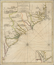
First state of Mortier's map of the Carolinas, one of the most detailed and up to date maps of period.
Mortier's map is based upon Thornton, Morden & Lea's virtually unobtainable map of the region, first published in 1685. Cumming observed that the two maps are identical to the smallest geographical detail and provide the most complete and up to date view of the Carolinas available at the end of the 17th Century. The original counties are named, and numerous estates and plantations are identified. The map includes an inset of Charleston, founded in 1669. One of the earliest obtainable maps of the region to reflect any significant settlement. Extends from Albermarle County to south of the Savannah River. Curiously, their is also large "Charles Ville ou Charles Town" shown next to Cape Fear, a reference to a short lived settlement in this established a few years prior to Charleston and abandoned a few years later. Please see
www.carolana.com/NC/Towns/Charles_Town_NC.html
for a more detailed history.
"Carolina was established in 1663 when Charles II granted the province to eight favorites, known as the Lord Proprietors, who had helped him regain the throne of England. The original grant included the territory between the 31st degree to 36 1/2 degrees north latitude, from Jekyll Island, Georgia, to Curritiuck Inlet, North Carolina. Two years later, the tract was enlarged to include the land between the 29th and the 31st degree north latitude, thus adding a large portion of Florida. The grant extended west to the Pacific Ocean" (
Degrees of Latitude, p.93). Carolina was divided into two separate colonies in 1712, and South Carolina received its royal charter in 1729.
A very nice example, lacking the plate number that distinguishes this map from the 2nd State, which was published by Covens & Mortier ca 1730.
Pierre, or Pieter, Mortier (1661-1711) was a Dutch engraver, son of a French refugee. He was born in Leiden. In 1690 he was granted a privilege to publish French maps in Dutch lands. In 1693 he released the first and accompanying volume of the Neptune Francois. The third followed in 1700. His son, Cornelis (1699-1783), would partner with Johannes Covens I, creating one of the most important map publishing companies of the eighteenth century.

![[Jefferson's Notes on the State of Virginia] Observations sur la Virginie [with the map:] A Map of the country between Albemarle Sound, and Lake Erie, comprehending the whole of Virginia, Maryland, Delaware, and Pensylvania, with parts of several other of the United States of America. Engraved for the Notes on Virginia.](https://storage.googleapis.com/raremaps/img/small/51828.jpg)