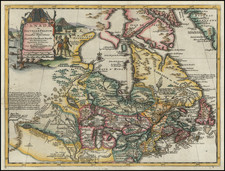
|
||

|

|
|

|
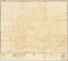
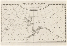
Detailed map showing the mining boom at the north end of the Portland Canal, along the Alaska-British Columbia border, near Hyder, Alaska and Stewart, British Columbia.
The map includes excellent detail with respect to the location of the glaciers, mines and topographical features of the region. About a dozen glaciers are located. The area was a mining region of considerable importance in the first part of the 20th Century. The area also shows both towns as thriving metropoli, with a well defined street grid, in comparison to their current conditions (Hyder, population 97 and Stewart, population 496). While it is possible that the map's street grids are made up, the current layout of Stewart suggests that the towns may both once have been laid out as shown.
The first exploration near Stewart took place in the late 1890's. Stewart was founded by two Scottish brothers, John and Robert Stewart, in 1905. By the peak of its first boom period, nearly 10,000 people resided in the area, although during World War I the population was reduced to less than 20 people.
Hyder, Alaska was originally called Portland City. The name was changed to Hyder in 1914 after Frederick Hyder, a Canadian mining engineer who predicted a bright future for the area. Hyder's boom years occurred between the years 1920 and 1930. By 1956, all major mining had closed except for Granduc Copper Mine in Canada, which operated until 1984.
Dalby Brooks Morkill (1880-1955) came to British Columbia in 1898, where he became one of the most prominent land surveyors in the region for the next 30 years. He received his commission as a British Columbia Land Surveyor in 1910. Morkill was employed in 1912 by the British Columbia government making surveys on the Fraser River, between Horsey Creek and Holmes River. In 1913, with Alan S. Thompson, Morkill surveyed between the Goat River and Catfish Creek. Morkill worked on the British Columbia-Alberta boundary surveys north of Yellowhead Pass in the early 1920s. Subsequently Morkill surveyed in several other areas of the Province, including the area around Stewart. The Morkill River Territory, Northwest of Jasper and Banff National Parks, are named for Morkill.
Dalby Brooks Morkill (1880-1955) came to British Columbia in 1898, where he became one of the most prominent land surveyors in the region for the next 30 years. He received his commission as a British Columbia Land Surveyor in 1910. Morkill was employed in 1912 by the British Columbia government making surveys on the Fraser River, between Horsey Creek and Holmes River. In 1913, with Alan S. Thompson, Morkill surveyed between the Goat River and Catfish Creek. Morkill worked on the British Columbia-Alberta boundary surveys north of Yellowhead Pass in the early 1920s. Subsequently Morkill surveyed in several other areas of the Province, including the area around Stewart. The Morkill River Territory, Northwest of Jasper and Banff National Parks, are named for Morkill.