


|
||

|

|
|

|
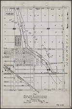
Important early manuscript map of the Yosemite (Valley) Lumber Company lands immediately south of Yosemite Valley and east of the Merced River,depicting the critical link between the Yosemite Valley Railroad and rail lines constructed by the company to bring timber from the company lands to a yet to be constructed mill in Merced, California. Dated March 15, 1911, the map is an important early snapshot of the final chapter of the logging industry within Yosemite National Park lands and includes the longest incline railway ever built, rising 3100 feet above the Merced River.
The Yosemite Lumber Company (which was apparently briefly also known as the Yosemite Valley Lumber Company) was created in the early 20th Century for the purpose of exploiting the rich timber reserves of the Yosemite area. The earliest reference to the tract of land shown in this map appeared on September 2, 1910 in the Merced County Sun:
The Sun has reference to the sale of about 10,000 acres of timber land, known as the Minor tract, to a new corporation known as the Yosemite Lumber Company. The land mentioned lies between the main Merced river and the south fork, on a line between Wawona and El Portal. This Minor tract includes 8000 acres, and other smaller pieces have also been purchased by the company, which will give them altogether about 10,000 acres, containing about 500,000,000 feet of lumber.
The deal involves a consideration of a half million dollars and another half million will be immediately expended on development work, so it may be said that it is a million dollar deal. The Yosemite Lumber Company is composed of capitalists headed by F. M. Fenwick, formerly manager of the Hammond Lumber Company of San Francisco, and one of the most prominent lumber operations on the Pacific coast. The company will proceed to establish a mill on the property and get the lumber out to market. El Portal will be the shipping point, and the lumber will be dropped down into the Merced river canyon at that point by means of an incline cable road about a mile in length.
This project means a vast deal to the Yosemite Valley Railroad Company and also to Merced City. The existence of that rich body of timber in the mountains was one of the chief factors that led the builders of the Yosemite Valley railroad to invest their capital in that enterprise. It was known that the passenger traffic of the road would not amount to enough, for several years at least, to clear a profit on the investment, but they knew that if the timber possibilities could be developed the road would derive a considerable tonnage from that source.
For a number of years this timber was held by several small owners, and about five years ago "Stony" Harris of Mariposa county got the owners to give options, and in this way the property fell into the hands of Mr. Minor and Charles Nelson, both big lumber men. Since the building of the Yosemite Valley railroad, the railroad people and especially Superintendent O. W. Lehmer, have been working energetically to get capitalists to take hold of the timber tract and develop it, and their labors finally resulted in the big deal being consummated in San Francisco last week.
As noted in an article which appeared in the Mariposa Gazzette on April 1, 1911, the lands shown on this map and the railroad line and tramway depicted were an intergral part of the development of the logging operations in the area:
...The Yosemite Lumber Company, which last year purchased 15,000 acres of timber land on the north fork of the Merced river in Mariposa county, has about completed arrangements for the development of the property. The plans include the construction of an incline railroad and establishment of a mill and a sash and door factory.
The incline railroad, which will be about six miles in length, will be built from the Yosemite Valley Railroad at a point near El Portal to the high tableland in the mountains between El Portal and Wawona, the power for transmission of the cars being furnished by a hoist at the top of the incline.
As described in the Mariposa Gazette, the map depicts (upper right corner) the El Portal terminus of the Yosemite Lumber Company's line at the point where it meets the Yosemite Railroad Company's line into the valley, along the with the surveyed and unsurveyed portions of its railroad lines within its tract of land, logging roads and a number of other points of interest. On July 1, 1911, the Merced Evening Sun noted the further progress of development of the line:
Contracts for the building of the inclined railroad from the Merced river at El Portal to the top of the mountain and into the timber belt on the high plateau above the canyon have been let to L. J. Scooffy of San Francisco. Mr. Scooffy's outfit of men and teams will pass through Merced to El Portal on or about July 8, and the work of grading and building the incline railway will be commenced in earnest as soon thereafter as camp is established. Engineer G. H. Nickerson has a corps of men now in the field working out all of the field and grade notes, setting the line and grade stakes and doing such other work preliminary to the grading and building of the road. The contracts held by Mr. Scooffy aggregate in the neighborhood of $150,000. The incline railroad from a point on the Merced river to the top of the mountain will be approximately 8000 feet in length, and will have a maximum grade of 30 percent.
In a later article on August 11, 1911, the Merced Evening Sun noted another of the features depicted on the map:
The first logging station in the woods will be located about two miles from the hoisting station. About four miles of logging road will be built into the timber this year, together with the necessary spurs and landings required in large logging operations. This road will be extended in length as required and will eventually reach a point in the vicinity of Wawona. The incline railroads, hoisting plant, logging roads and permanent camps in the timber are to be ready for logging operations to commence about May 1, 1912.
The line opened in August 1912 and was heralded as a great success and by mid -1913, the Yosemite Lumber Company had acquired more than 50,000 addition acres of land, resulting in a period where the lands were logged very actively by the company. With only a few years, interest in preserving the land against logging galvanized at the local and Federal level, resulting in the commencement of a program to trade lands within the park for lands outside the park. The land shown on this map was, for instance, the subject of a section of the Report of the Director of the National Park Service to the Secretary of the Interior (1921), wherein the Director reports at page 195:
While the exchange [of timber lands] with the Yosemite Lumber Co.. . has not been consummated, it is still in negotiaton, and without doubt before another season opens will be completed. This exchange contemplates an exchange of a considerable block of standing timber owned by the Yosemite Lumber Co. in the Grouse Creek watershed and in the lower Indian Creek Valley for Government-owned timber of equal value in less valuable park areas in the western part of the reservation. The consummation of this exchange means the complete preservation of an effective timber screen along Wawona Road, which area would have been completely denuded of all timber had not exchanges been made with the Yosemite Valley Lumber Co., who orignally owned both land and timber in this area.
The present map is a remarkable artifact of this important transitional period in the history of the park, depicting the lands as they existed immediately prior to the commencement of construction on the railroad line and logging operations which would commence the final chapter in the private history of this part of the park.
![Lands of the Hemet Land Co. [Hemet Southern California. Its homes and scenes]](https://storage.googleapis.com/raremaps/img/small/89106.jpg)