|
||

|

|
|

|
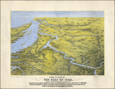
Rare Civil War map showing the area around Richmond, Virginia, published after the Battle of Spotsylvania Court House in May 1864 (the Battle Ground is shown and dated in the map).
The map extends from Washington DC to Norfolk, Virginia, and inland to Charlottesville. Includes towns, rivers, court houses, roads, railroads, etc. During the Civil War, interest in the Theater of War was high and a number of local printers published maps depicting the progress of the War. The present plan is one of the rarest, with no appearances in auction records or AMPR over the past 25 years and only 4 institutional copies located (Library of Congress, Penn State, Harvard and Cincinnati Public Library). At the time of this catalog entry, a second copy was on the market (Lan, June 2009), although the present example is in much better condition.
Maps of this type were very ephemeral and few have survived. The present example, published by Benjamin B. Russell and Forbes & Company, seems to have been the precursor to several other maps of the area around Richmond published at the time, including A Complete Map of Richmond and its Fortifications within a Circle of 12 Miles and Forbes' New and Complete Map of Richmond and its Fortifications (published by Forbes & Co) and Forbes' New and Complete Map of Richmond and its Fortifications (published by Forbes & Russell).
The partnership of Forbes and Russell was either short lived or perhaps non-existent. Forbes began as a young journeyman printer in 1862 and within 10 years would establish one of the largest and most successful commercial printing and lithography businesses in America, which by the 20th Century had also established itself in London. Benjamin B. Russell began his career in Dover, New Hampshire in about 1854 and by the early 1860s seems to have established himself in Boston as a printer and stationer, whose output seems to have been primarily sermons, sheet music, guidebooks and Civil War related items. He is listed as the second publisher with Schonberg & Co. of Schonberg's Standard Atlas of the World (1864) and also published. The New War Map of Maryland, part of Virginia & Pennsylvania (1863--also printed in blue), The Historical War Map (with Asher & Co.; 1862), Russell's Map of Massachusetts (with J. Mayer & Co.; 1869); Russell's Map of Boston from the latest Surveys (1868); and Russell's Map of Paris and Fortifications (ca 1870), along with Nutting's Bird's-eye view of Boston (1868). He may have been related to John Russell, publisher of Russell's New Map of Portand Maine (1869), as his name also appears as publisher of this map.
A fine example of this rare and interesting map.

![[ First Map of Pennsylvania Province ] A Map of the Province of Pensilvania Drawn from the Best Authorities By T. Kitchin Gr.](https://storage.googleapis.com/raremaps/img/small/98226.jpg)
![[ Florida Indians - Destroying the Enemy's Towns By Night ] Hostium oppida noctu incendendi ratio. XXXI.er absagen](https://storage.googleapis.com/raremaps/img/small/97385.jpg)