|
||

|

|
|

|
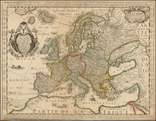
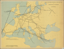
First state of Willem Janszoon Blaeu's extremely rare sea chart of Europe, printed circa 1621.
Blaeu's chart was highly influential and was later copied by Anthonie Jacobsz, Pieter Goos and Justus Danckerts, as well as by Blaeu's own grandchildren Willem, Pieter and Joan. Frederick De Wit also made a copy of the map map which cut off the region that included Greenland, which was copied by Renard and Ottens. The chart is among Blaeu's earliest separately issued maps, at a time when he was making a name for himself in Amsterdam as a maker of Globes, Instruments and Wall Maps. Several of Blaeu's maps, including this map and his 10 sheet map of the Low Countries, were used by the Dutch Master Painter Vermeer in a series of paintings depicting a Map and Globe maker in his workshop.
The chart is oriented with west towards the top and extends from Novaya Zemla in the east to the Azores in the west, and from the northern coast of Spitzbergen to the Canary Islands in the south. The eastern portion of the Mediterranean is depicted within the interior of North Africa. Magnificently decorated, there are richly detailed European coats of arms, scale cartouches in the corners, several ships in the waters, a pair of native people in Greenland, and a number of animals portrayed on land, including polar bears and elephants.
Pieter Goos re-issued the map using the original Blaeu plate, and Gunther Schilder dates this state between1650 and 1666, noting that "the text in the title cartouche, still crowned by the printer's mark of Blaeu, has been replaced and a new imprint has been placed in a new, richly decorated cartouche in Greenland."
Schilder notes eight examples, none in US or British Institutional Collections: (Universiteitsbibliotheek Amsterdam; Stadsarchief Antwerpen; Staatsbibliothek zu Berlin; Nationalbibliothek Budapest; Hessesche Landesbibliothek, Darmstadt; Badische Landesbibliothek, Karlsruhe; BNP; Herzogin Anna Amalia-Bibliothek, Weimar; and Collectio Stopp).
Willem Janszoon Blaeu (1571-1638) was a prominent Dutch geographer and publisher. Born the son of a herring merchant, Blaeu chose not fish but mathematics and astronomy for his focus. He studied with the famous Danish astronomer Tycho Brahe, with whom he honed his instrument and globe making skills. Blaeu set up shop in Amsterdam, where he sold instruments and globes, published maps, and edited the works of intellectuals like Descartes and Hugo Grotius. In 1635, he released his atlas, Theatrum Orbis Terrarum, sive, Atlas novus.
Willem died in 1638. He had two sons, Cornelis (1610-1648) and Joan (1596-1673). Joan trained as a lawyer, but joined his father’s business rather than practice. After his father’s death, the brothers took over their father’s shop and Joan took on his work as hydrographer to the Dutch East India Company. Later in life, Joan would modify and greatly expand his father’s Atlas novus, eventually releasing his masterpiece, the Atlas maior, between 1662 and 1672.
![(Prussian Octopus) En 1788 Mirabeau disait deja: La Guerre est l’industrie Nationale de la Prusse [Already in 1788 Mirabeau was saying: War is the national industry of Prussia]](https://storage.googleapis.com/raremaps/img/small/76554.jpg)