The item illustrated and described below is sold, but we
have another example in stock. To view the example which
is currently being offered for sale, click the
"View Details" button below.


|
||

|

|
|

|
Stock# 21228
Description
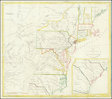
Interesting map of the United States with large inset of the South Carolina and Georgia.
The map extends east to include the confluence of the Kentucky and Ohio Rivers and names Kentucky, but not Ohio or Tennessee. Includes nice detail in the Trans-Appalachian and Trans-Allegheny regions and includes Weld's route through Virginia. A note in the upper left corner identifies the regions in which the Christian Indians reside. An interesting 18th Century map of the United States.
![(The First Letter From British Florida) [September 5, 1763, Autograph Letter, Signed, from Robert Campbell to John Campbell, 4th Earl of Loudoun, describing the British taking possession of Florida and the state of the settlement of Pensacola]](https://storage.googleapis.com/raremaps/img/small/86620.jpg)
![[ Atlas - Florida and Southern Canal Projects ] Travaux d'améliorations intérieurs projetés ou exécutés par le gouvernement général des États-Unis d'Amérique, de 1824 à 1831 [complete with:] Travaux d'améliorations intérieurs projetés ou exécutés... Atlas.](https://storage.googleapis.com/raremaps/img/small/85067.jpg)
![[ First Gold Rush Edition! ] Colton's Map of the United States of America, The British Provinces, Mexico, The West Indies and Central America . . . 1849](https://storage.googleapis.com/raremaps/img/small/101951.jpg)