
This item has been sold, but you can enter your email address to be notified if another example becomes available.


|
||

|

|
|

|
Stock# 21047
Description
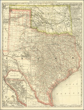
Detailed map of the region between Weathford, Texas (just west of Fort Worth) to Jones, Taylor and Runnels Counties.
While the map includes some hydrographical and topographical detail, the primary purpose of the map seems to be Railroad lines and distances, and was perhaps a survey map for transporation routes in the 1870s. General McKenzie's trail is noted.
The McKenize Trail was made and used by the 4th US Calvary 10th and 11th US infantry's under command of general Ranald Slidell McKenzie in their Indian campaigns of 1871 to 1875 Soldier Mound 4 miles north of this spot was one of the important bases of operations. McKenzie batteled predatory bands of Comanche's, Cheyenne, Kiowas, Arapaho's, in West Texas.
Condition Description
Pen and Ink on linen. Flattened on thicker archival paper board.
![[Republic of Texas] Texas](https://storage.googleapis.com/raremaps/img/small/94176.jpg)

![[Matagorda Bay] Bahia De S. Bernardo](https://storage.googleapis.com/raremaps/img/small/54374.jpg)