|
||

|

|
|

|
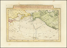
Rare pair of maps on a single sheet, illustrating the Straits of Magellan and the unknown Southern Continent.
The map is divided into two sections. The top half is drawn on normal projection and shows the bottom of South America, separated by a strait from a large Southland (Australis Terre Pars). The naming of C. Della Victoria and the illustration of Magellan's ship the Victoria indicates Maggellan's discovery of the strait that now bears his name. The south section is drawn on polar projection and shows a large Terra Australis reaching up in four peninsulas towards New Guinea (here shown as an island), 'Java Maior', Africa and towards South America. On the Southland just below 'Java Maior' are indicated three place names - Maletur Regnum, Beach (based upon Marco Polo's Account) and Lucach Regnum.
Matthias Quad (1557-1613), a map publisher based in Cologne, was trained in the Netherlands by Johannes van Doetecum, who also worked with the De Jodes. Quad used many De Jode maps as a base to which he added additional information and decorations. Quad was best known for his atlases, which were part of the first boom in atlases best characterized by Abraham Ortelius’ Theatrum Orbis Terrarum. In 1592, Quad released an atlas of Europe that had 38 maps. He expanded it in 1594 to 50 maps. In 1600, he expanded the collection of maps further still, this time to 82 maps, and called the atlas, Geographisch Handtbuch. All three were small in size, allowing them to compete as cheaper alternatives to the larger atlases of Ortelius, Mercator, and the De Jodes. Quad released one other atlas, in 1608, with 86 maps, the Fascilus Geographicus.

![[ South America ] Carte Encyprotype, de l' Amérique Meridionale . . . 1816 [Wall Map]](https://storage.googleapis.com/raremaps/img/small/69010.jpg)