


|
||

|

|
|

|
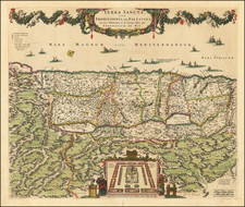
Old color example of De Wit's map of the Holy Land, oriented to the West, and divided among the Tribes of Israel on both sides of the Jordan.
The shore line runds from Sidon to Egypt. The Kishon River connects Haifa Bay to the Lake of Tiberias. Along the top, a garland is supported by 6 cherubs. At the bottom center, the encampment of the Tribes in the desert surrounding the Tabernacle, flanked by Moses and Aaron. The map is drawn from Visscher's map of 1659, with minor changes. Richly embellished and highly detailed.
De Wit (1629 ca.-1706) was a mapmaker and mapseller who was born in Gouda but who worked and died in Amsterdam. He moved to the city in 1648, where he opened a printing operation under the name of The Three Crabs; later, he changed the name of his shop to The White Chart. From the 1660s onward, he published atlases with a variety of maps; he is best known for these atlases and his Dutch town maps. After Frederik’s death in 1706, his wife Maria ran the shop for four years before selling it. Their son, Franciscus, was a stockfish merchant and had no interest in the map shop. At the auction to liquidate the de Wit stock, most of the plates went to Pieter Mortier, whose firm eventually became Covens & Mortier, one of the biggest cartography houses of the eighteenth century.
![[Jerusalem's Two Hills] Hierosolyma, Clarissima Totius Orientis Civitas Iudaee Metropolis . . .](https://storage.googleapis.com/raremaps/img/small/74099.jpg)
![A New Map Shewing all the several Counties, Cities, Towns, and other Places mentioned in the New Testament . . . [shows Cyprus]](https://storage.googleapis.com/raremaps/img/small/90593.jpg)