
![[Separately Published Example!] Map of the United States of America. Designed to illustrate the Geological Memoir of Wm. Maclure Esq. By John Melish / Charles Alexandre Lesueur](https://storage.googleapis.com/raremaps/img/small/90048.jpg)


|
||

|

|
|

|
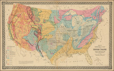
In 1809, William Maclure utilized a map of the United States by Samuel Lewis and super-imposed geological information by handcoloring the map to show geological formations, thereby creating the first thematic map produced in America. The map was reissued in the Transactions of the American Philosophical Society Vol. I New Series in 1817, with a new map published by John Melish in Philadelphia. The map itself is quite wonderful, showing the usual Melish attention to detail and the newest information, showing Illinois Territory, Mississippi and Alabama Territories, Missouri Territory, a number of western forts and Indian settlements, treaty boundaries, western roads, etc., in addition to the Geological information. Schwartz & Ehrenberg 225.
John Melish (1771-1822) was the most prominent American mapmaker of his generation, even though his cartographic career lasted only a decade. Melish was born in Scotland; he moved to the West Indies in 1798 and then to the United States in 1806. By 1811, he had settled in Philadelphia and published Travels through the United States of America, in the years 1806 & 1807, and 1809, 1810, & 1811, which was richly illustrated with maps.
Melish created several regional maps of the highest quality, as well as the Military & Topographical Atlas of the United States (Philadelphia, 1813, expanded 1815). The latter work is widely considered to be the finest cartographic publication to come out of the War of 1812.
By far his best-known work is his monumental map of the United States of 1816, Map of the United States with the contiguous British and Spanish Possessions. He began working on the map in 1815 and sent it to Thomas Jefferson for comment in 1816. Jefferson enthusiastically reviewed the map and returned it with his edits. Jefferson later hung an example of the map in the Entrance Hall of Monticello and sent it to associates in Europe.
Melish’s finished product was the first map of the United States to extend to the Pacific Ocean. After its publication in 1816, Melish ensured the map was as up-to-date as possible; it was reissued in 25 known states published between 1816 and 1823. The map captured the then rapidly changing geography of the United States, as well as various boundary disputes, treaties, and expansion.

![(French & Indian War) The New Map of the British Dominions in North America; with the Limits of the Government annexed thereto by the late Treaty of Peace, and settled by Proclamation October 7th, 1763 [in:] The Annual Register, or a View of the History, Politicks, and Literature, for the Year 1763. Volume 6](https://storage.googleapis.com/raremaps/img/small/77573.jpg)
![[ Atlantic Ocean / Triangular Trade / Negroland ]](https://storage.googleapis.com/raremaps/img/small/65187.jpg)