|
||

|

|
|

|
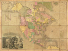
Striking large format map of the United States by Pierre Tardieu, one of the best engraved large format maps of the United States from the period.
Tardieu's map is based upon the true first state of Arrowsmith's map of the United States, which has been completely re-engraved by Tardieu, and reflects the finer engraving skills of this Paris engraver. In addition to the decorative cartouche present in Arrowsmith's map, Tardieu has added a plan of Washington DC, based upon Ellicott's plan.
The map is a landmark of American Cartography prior to Lewis & Clark. The interior detail of the trans-Mississippi west was compiled largely from accounts supplied by Native Americans to Arrowsmith, by the Hudson's Bay Company. The course of the Missouri River delineated on the map prompted Lewis and Clark to plot their course along the Missouri River, as it appeared to be the most direct route to the Pacific. This is the first edition of the map.
The present map came to the attention of Thomas Jefferson, who specifically reached out to the Tardieu family to update the map. The Tardieus exchanged maps with Thomas Jefferson on several occasions, specially in aid of the Tardieu's efforts to incorporate information from Lewis & Clark and others into their maps (see, e.g. letter from P.A.F. Tardieu to Jefferson dated May 30, 1809. www.loc.gov/item/mtjbib019962/ ). Thomas Jefferson wrote to Tardieu on one occasion, thanking him for his excellent maps of the United States and the Bay of Mexico, and in return, Jefferson sent Tardieu a survey of the Mississippi River from its source to the mouth of the Ohio, and promises a map of Louisiana from "Gov. Lewis, who conducted the journey to the South Sea as soon as it appears."
All editions are rare, but we have never before seen an example of the 1802 edition.
Pierre Antoine Tardieu (1784-1869), also known to sign his works as PF Tardieu, was a prolific French map engraver and geographer. The Tardieu family, based in Paris, was well known for their talent in engraving, cartography, and illustration. Pierre Antoine’s father, Antoine Francois Tardieu, was an established cartographer who published numerous atlases. His son is said to have collaborated with him for many years before establishing his own independent career.
Pierre Antoine Tardieu’s most famous work includes engravings of the islands of La Palma and Tenerife, for which in 1818 he was awarded a bronze medal by King Louis-Phillipe for the beauty and accuracy of his mapping. Other famous work includes his mapping of Louisiana and Mexico, engravings of Irish counties, maps of Russia and Asia, and his highly celebrated illustrations of all the provinces of France. He was also the first mapmaker to engrave on steel.
Tardieu was a popular map engraver in his lifetime, enjoying the patronage of the likes of Alexander von Humboldt and respect among his peers. In 1837, he was appointed the title Chevalier de la Légion d’honneur. As was written in his obituary in the Bulletin of the Geographical Society of France, he was renowned for his combination of technical talent and scholarly research skills and praised for furthering his family’s well-respected name in the scientific arts.

![[United States]](https://storage.googleapis.com/raremaps/img/small/93852.jpg)