


|
||

|

|
|

|
Detailed map of a portion of the mining regions of California, showing the area from Bouldin Island (just west of the City of Stockton) to Yosemite and from Amador County south to the Merced River.
The map includes remarkable detail in the mining regions of California, including a very detailed treatment of the Sierra Railway and the West Side Flume and Lumber Company Rail Road lines. Shows drainage, mines, railroads, stage roads, county roads, electric flumes, county lines, etc.
Title on cover: P.A. Buell's map of a part of California showing the great Mother Lode mineral belt ...
Relief shown by hachures. P.A. Buell operated on of the largest lumber yards in Stockton at the end of the 19th Century.
Rarity
The map and pamphlet are rare, with only 3 examples listed in OCLC (California State Library, Bancroft, Denver Public Library).


![[ Before The Salton Sea ] [ Official Map of San Diego County compiled from latest official maps of U.S. surveys, railroad and irrigation surveys, county records, and other reliable sources . . . Northeast Sheet ]](https://storage.googleapis.com/raremaps/img/small/101378.jpg)
![[ Huntington Beach Infrastructure Map -- Newport Beach to Long Beach ]](https://storage.googleapis.com/raremaps/img/small/98369.jpg)
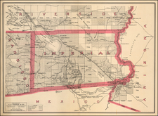
![[Imperial Valley]](https://storage.googleapis.com/raremaps/img/small/69292.jpg)