


|
||

|

|
|

|
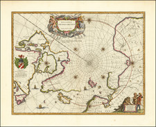
A nice example of the scarce first state of Blaeu's signature map of the North Polar Regions, with several wonderful cartouches and decorative coat of arms.
The first state of Blaeu's decorative map of the North Pole, including Arctic North America, Scandinavia and northern Asia. The information for this map is based on the discoveries of James, Barentsz, Baffin, Frobisher, Hall, Davis, and others. In particular, this map incorporates the discoveries of James along the southern and western shore of Hudson's Bay in 1631-32 and promotes the view that the famous "Northwest Passage" across northern North America did not exist.. The map's detail would suggest the existence of a north-east passage as the coastline appears in tact and the sea clear and without any barrier to progress. The Canadian Arctic waters, however, appear almost landlocked lacking any promise of a north-west route to the Indies.The map was revised in 1645, with the addition of the coats of arms of dedicatee Gulielmo Backer.
Willem Janszoon Blaeu (1571-1638) was a prominent Dutch geographer and publisher. Born the son of a herring merchant, Blaeu chose not fish but mathematics and astronomy for his focus. He studied with the famous Danish astronomer Tycho Brahe, with whom he honed his instrument and globe making skills. Blaeu set up shop in Amsterdam, where he sold instruments and globes, published maps, and edited the works of intellectuals like Descartes and Hugo Grotius. In 1635, he released his atlas, Theatrum Orbis Terrarum, sive, Atlas novus.
Willem died in 1638. He had two sons, Cornelis (1610-1648) and Joan (1596-1673). Joan trained as a lawyer, but joined his father’s business rather than practice. After his father’s death, the brothers took over their father’s shop and Joan took on his work as hydrographer to the Dutch East India Company. Later in life, Joan would modify and greatly expand his father’s Atlas novus, eventually releasing his masterpiece, the Atlas maior, between 1662 and 1672.

![[ Queen Anne's War - Failed Attack on French Canada -- Petition to Queen Anne from the Colony of New York seeking reimbursement for a failed conquest of New France during Queen Anne's War ] To the Queens most Excellent Majesty . . . 1709](https://storage.googleapis.com/raremaps/img/small/85409.jpg)