
![A Map of North America, Constructed According To The Latest Information: by H.S. Tanner. Improved to 1825 [Case Map] By Henry Schenk Tanner](https://storage.googleapis.com/raremaps/img/small/68580.jpg)


|
||

|

|
|

|
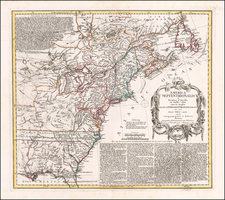
Tanner's landmark map of North America, first issued in 1822, is amount the most important North American maps of the 19th Century. The map illustrates the extent of the discoveries of Lewis & Clark and combines the information from the expeditions of Pike, James and a host of other overland surveys into this spectacular large format work.
The map was issued separately and also bound in four sheets into Tanner's New American Atlas, which was issued in serial subscription format and later as a bound volume, beginning in 1823. The treatment of the Mississippi and Missouri Valleys is extraodinary, as is the detail along the Columbia River Basin. The map also illustrates the two mythical rivers flowing from the area just west of the Rocky Mountains to the Pacific, draining the mythical lakes of Timpanagos and Teguayo. Tanner's treatment of the Rocky Mountain Region, Texas, Oregon Territory and Hudson Bay Company lands are also truly noteworthy.
Tanner's map is one of the milestone's in American map making, both for its content and beauty.
![(American Revolution) Geschichte der Revolution von Nord-America. Sammlung der besten Schriftsteller, welche die Geschichte, besondere Rechten, Sitten, und Gewohnheiten der Völker nach ihren Grundsätzen abgehandelt haben [with map:] Die Vereinigten Staaten von Nord=America. nach der Wm. Faden 1783. [History of the Revolution of North America. Collection of the Best Writers Who Have Discussed the History, Specific Laws, Customs, and Habits of the Peoples According to Their Principles [with map:] The United States of North America. According to Wm. Faden, 1783.]](https://storage.googleapis.com/raremaps/img/small/90124.jpg)
![[ United States ] Etats-Unis de l'Amerique](https://storage.googleapis.com/raremaps/img/small/98821.jpg)