This item has been sold, but you can enter your email address to be notified if another example becomes available.


|
||

|

|
|

|
Stock# 20111
Description
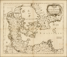
Scarce sea chart of the Nord Zee and Oost Zee, including parts of the coast of Sweden, Norway, Denmark, Germany and Holland. Includes a decorative cartouche, two vignettes of sailing ships and compass rose.
Originally issued by De Wit, Renard published this map from 1715 to 1739, after which time it was published by Ottens. The Renard edition of the map is quite scarce.
Condition Description
Fine dark impression. Clean wide margins.
![[Rhine River] Nova Totius Rheni Descriptio ex celeberrimis et varijs Autoribus, in unam tabulam redacta . . . 1672](https://storage.googleapis.com/raremaps/img/small/62395.jpg)
![[Zandvliet] Caerte van't Scheldt ende Santvliet; Vertoonede de verdroncken overwaterde Landen, nieuw aengewasse gorsingen, en de kreeken ost killen in en door de Selve tussche Begen op Zoom en Antwerpen. Van nieus Verbetert door C.J. Visscher. 1640](https://storage.googleapis.com/raremaps/img/small/75366.jpg)
![[Environs of Amsterdam]](https://storage.googleapis.com/raremaps/img/small/75544.jpg)