


|
||

|

|
|

|
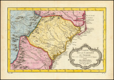
Colored example of the reduced version of Speed's map of Virginia and Maryland.
The map is derived from Smith's 1612 map of Virignia, but also is one of the first maps to incorporate the information from Augustine Hermann's exceedingly rare and important map, issued in 1673. This reduced example of the map does not extend as far south and is more focused on the Chesapeake region than the larger format edition, which appeared in Speed's Prospect.
The map shows the 1668 border settlement between Virginia and Maryland and an improved treatment of Delaware Bay and River. The Northeastern shore of the Chesapeake is also greatly improved from Smith's map. Burden refers to the map as an important transitional map between Smith and Hermann.
The reduced edition is also scarcer than the large format edition and appears less frequently on the market.
John Speed (1551 or '52 - 28 July 1629) was the best known English mapmaker of the Stuart period. Speed came to mapmaking late in life, producing his first maps in the 1590s and entering the trade in earnest when he was almost 60 years old.
John Speed's fame, which continues to this day, lies with two atlases, The Theatre of the Empire of Great Britaine (first published 1612), and the Prospect of the Most Famous Parts of the World (1627). While The Theatre ... started as solely a county atlas, it grew into an impressive world atlas with the inclusion of the Prospect in 1627. The plates for the atlas passed through many hands in the 17th century, and the book finally reached its apotheosis in 1676 when it was published by Thomas Bassett and Richard Chiswell, with a number of important maps added for the first time.


![[A chart of New York Island & North River: East River, showing passage through Hell Gate, and the North Shore of Long Island: Flushing Bay, Hampstead Bay, Oyster and Huntington Bay, Cow Harbor]](https://storage.googleapis.com/raremaps/img/small/51531.jpg)
![[First Sea Chart of New Netherlands] Pascaarte van Nieu Nederlandt uytgegeven door Arnold Colom](https://storage.googleapis.com/raremaps/img/small/46535.jpg)