


|
||

|

|
|

|
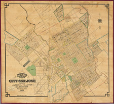
One of the earliest separately issued large format maps of San Jose, California.
Other than Thomas White's map of 1850 and and George Hare's map of 1872 (both considerably smaller), this map is perhaps the earliest separately issued map of San Jose and quite possibly the rarest. The map identifies the City Limits, a number of eary Additions and Subdivisions, several areas noted as Surveys and Tracts, the Convent of Notre Dame, St. James Square, Washington Square, the State Normal School, and a series of concentric circles marking the distnce from the corner of First & Santa Clara.
Of note, there is a pastedown label noting the transfer of the rights to the map to F.A. Taylor, Newsdealer.
San Jose was founded on November 29, 1777 as Pueblo de San Jose de Guadalupe, the first civil settlement in Alta California. In 1797, the pueblo was moved to the location which became the modern Downtown area. After passing from Spanish to Mexican control, the city became part of the United States in 1846. On March 27, 1850, San Jose became the second incorporated city in the California (after Sacramento).
James A. Clayton was born in England in 1831 and moved to the US in 1839, settling in Iowa County, Wisconsin in 1840. Clayton and his brother Joel Clayton came to California in August 1850, staying briefly in the Gold Mining Regions before coming to Santa Clara on August 25, 1850, where he joined his brother Charles Clayton, who had arrived in 1848. James returned to the Gold Regions in February 1851, then on to try the gold mines of Australia in November 1851. He returned to California in August 1852, staying briefly in Stockton,before returning to Santa Clara.
James Clayton settled in San Jose in January 18665, where he purchased a photograph gallery on Santa Clara Street, which he later moved to Spring's corner. He operated the business for 13 years. In 1861, he was elected County Clerk. In 1867, established a real estate office, where he became the major real estate broker in the area, remaining so until his death in April 1896.
![[The Indian Tribes of California] Karte Übersicht zur Verbreitung der Indianer-stämme in Kalifornien](https://storage.googleapis.com/raremaps/img/small/96549.jpg)
![[ Chinese Voyages To America, etc. ] Memoires De Litterature, Tires Des Registres De L'Academie Royale Des Inscriptions et Belles-Lettres Depuis l' annee M. DCC. XVIII. julques & compris l'annee M. DCC. XXV Tome Quarante-Neuvieme](https://storage.googleapis.com/raremaps/img/small/101296.jpg)
![[Southwest Riverside County] Elsinore Quadrangle](https://storage.googleapis.com/raremaps/img/small/83490.jpg)