


|
||

|

|
|

|
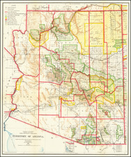
Detailed separately issued General Land Office map of Arizona Territory.
The map identifies the office of the Surveyor General, US Land Offices, County Seats, completed railroads, railroad land grant limits, military reservations, private grants confirmed, private grants unconfirmed, Indian Reservations, counties and townships. Includes Indian Reservations, Township Surveys, Roads, Mountains, Rivers and a host of other fine details.
The map was prepared by A.F. Dinsmore. It is one of the largest obtainable maps of Arizona Territory and one of the most detailed from this period.
The General Land Office (GLO) refers to the independent agency in the United States that was in charge of public domain lands. Created in 1812, it assumed the responsibilities for public domain lands from the United States Department of the Treasury. The Treasury had overseen the survey of the Northwest Territory, but as more area was added to the United States, a new agency was necessary to survey the new lands.
Eventually, the GLO would be responsible for the surveying, platting, and sale of the majority of the land west of the Mississippi, with the exception of Texas. When the Secretary of the Interior was created in 1849, the GLO was placed under its authority. Until the creation of the Forest Service in 1905, the GLO also managed forest lands that had been removed from public domain. In additional to managing the fees and sales of land, the GLO produced maps and plans of the areas and plots they surveyed. In 1946, the GLO merged with the United States Grazing Service to become the Bureau of Land Management.

![[Report and] Map of an Exploring Expedition to The Rocky Mountains in the Years 1842 and to Oregon & North California in the Years 1843-44 By Brevet Capt. J. C. Fremont of the Corps of Topographical Engineers . . .](https://storage.googleapis.com/raremaps/img/small/88488.jpg)