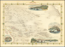
|
||

|

|
|

|
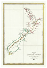
Detailed chart of the Thames River and Mercury Bay with insets of The Bay of Islands, and Tolaga Bay, from the first French edition of the official account of Cook's Voyage to New Zealand.
The map is based on surveys brought back to England at the end of Capt. James Cook's first voyage to the Pacific and New Zealand which lasted 3 years from 1768-1771. In 1769 Cook's ship the Endeavour sailed along the east coast of New Zealand's North Island, and anchored briefly in an inlet that Cook named Tolaga Bay, where the crew took on supplies of wood and water. Continuing along the coast Cook found a large bay whose shores were lushly cultivated, and so he aptly named it Bay of Plenty.
Anchoring on the west side of the Bay, Cook and Charles Green went ashore to observe the transit of Mercury across the Sun. Cook named the region Mercury Bay. From there, Cook continued along the coast until a river was sighted. Cook went ashore in what is now Hauraki Gulf. The river reminded him so much of the Thames in London, that he named it the Thames River or River Tamise.
![[ New Zealand ] To the Right Honourable The Secretary of State for the Colonies &c. &c. &c. This Chart of New Zealand, from Original Surveys . . . Third Edition . . .](https://storage.googleapis.com/raremaps/img/small/70538.jpg)