|
||

|

|
|

|
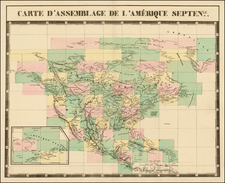
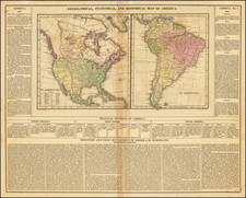
Rare map of North America published in Paris, one of the earliest examples of the use of Lithography for the printing of maps.
The publisher employs a curious manuscript style, which is also very unusual and may have been augmented by an early hand. A table in the right shows the dates of the formation of each of the US States and Territories, up to Oregon Territory, Northwest Territory, Missouri and Michigan Territory in 1823. The mythical western rivers are shown flowing from various mythical lakes and other sources to the Pacific. Marvelous depiction of Russian America, complete with placenames.
An extremely early example of lithography on French maps, perhaps the earliest we have ever seen. The first lithographic atlas was published in Brussels by Philippe Vandermaelen in 1827, so this is quite possibly the second earliest example of the use of lithography in an atlas. A fascinating map, appealing for both its early use of lithography and curious presentation.
![[United States Independence After The Revolution] A New Map of North America, with the West India Islands, Divided according to the Preliminary Articles of Peace, Signed at Versailles, 20 Jan. 1783, wherein are particularly Distinguished The United States, and the Several Provinces, Governments &ca, which Compose the British Dominions . . . 1783](https://storage.googleapis.com/raremaps/img/small/70734.jpg)