|
||

|

|
|

|
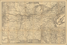
Fascinating example of Holt's new enlarged map of Wyoming, the most important separately issued map of Wyoming of the period.
The present example has been extensively annotated by an engineer working for the Union Pacific Railroad and includes proposed rail lines, stations and a host of other details in both black, blue and pink, plus proposed counties stenciled on to the map, which did not exist at time the map was printed.
G.L. Holt's maps of Wyoming are the earliest commerically published maps of Wyoming to show the Territory in significant detail. Holt's maps were produced between 1883 and ca.1890. They show the development and settlement of Wyoming and include the location of some early ranches and trails. Rumsey describes the map as an outstanding map full of interesting detail on all matter of subjects. Wheat states that students of early Wyoming history will sometimes find Holt their most helpful cartographic tool. Holt advertised the map as the only reliable and accurate map of Wyoming ever published. The decorative vignettes show cattle ranching and early manufacturing scenes. One of the most important early Wyoming maps.
A fine example, embellished with extensive contemporary notes.
G. W. & C. B. Colton was a prominent family firm of mapmakers who were leaders in the American map trade in the nineteenth century. The business was founded by Joseph Hutchins Colton (1800-1893) who bought copyrights to existing maps and oversaw their production. By the 1850s, their output had expanded to include original maps, guidebooks, atlases, and railroad maps. Joseph was succeeded by his sons, George Woolworth (1827-1901) and Charles B. Colton (1831-1916). The firm was renamed G. W. & C. B. Colton as a result. George is thought responsible for their best-known work, the General Atlas, originally published under that title in 1857. In 1898, the brothers merged their business and the firm became Colton, Ohman, & Co., which operated until 1901, when August R. Ohman took on the business alone and dropped the Colton name.
![Charte von Den Vereinigten Staaten von Nord-America nebst Louisiana . . . 1805 [Rare 1st State of Gussefeld's Louisiana Purchase Map]](https://storage.googleapis.com/raremaps/img/small/63496.jpg)