


|
||

|

|
|

|
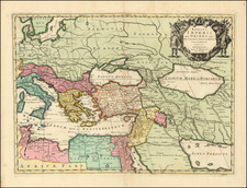
Striking large format map of the course of the Danube, from its source to the Black Sea.
A large and decorative map of the Danube from Jaillot's Atlas Nouveau. Based on the Coronelli map published by Nolin in 1688, the fine baroque title features medallion portraits of Pope Innocent XII, the Holy Roman Emperor, and the kings of Poland, Hungary and Bavaria. Underneath are five prospects of fortress towns and a chart of the Bosphorus.
Alexis-Hubert Jaillot (ca. 1632-1712) was one of the most important French cartographers of the seventeenth century. Jaillot traveled to Paris with his brother, Simon, in 1657, hoping to take advantage of Louis XIV's call to the artists and scientists of France to settle and work in Paris. Originally a sculptor, he married the daughter of Nicholas Berey, Jeanne Berey, in 1664, and went into partnership with Nicholas Sanson's sons. Beginning in 1669, he re-engraved and often enlarged many of Sanson's maps, filling in the gap left by the destruction of the Blaeu's printing establishment in 1672.
![[ Odessa ] Генеральный Планъ Города Одессы съ Принадлежащею Оному Землею Раздѣленною на 6ть Частей съ показанiемъ Предмѣстiй, селенiй, хуторовъ, садовъ и другихъ Казенныхъ и частныхъ заведенiй. [General Plan of the City of Odessa...]](https://storage.googleapis.com/raremaps/img/small/56509.jpg)