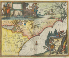
![A New and Exact Map of the Dominions of the King of Great Britain on ye Continent of North America . . . [Beaver map] By Herman Moll](https://storage.googleapis.com/raremaps/img/small/101277.jpg)


|
||

|

|
|

|
One of the most famous maps of Colonial America. The map was prepared along with the Codfish Map as Moll's pictorial counterclaims to offest the earlier maps of De L'Isle, especially the descriptions of the lands west of the Alppalachian mountains. The map is also the first map to show postal routes in North America and includes an important map of Carolina as an inset. The map is heavily annotated with details of British settlements, colonial claims and, Indian tribes and claims and a host of other information, far too much to mention here. The inset of the Beavers at Niagara Falls became a standard symbol for many years. Schwartz & Ehrenberg, Plate 78 & 79. A strong example, lacking the usual fold browning and w/only minor restorations.
Herman Moll (c. 1654-1732) was one of the most important London mapmakers in the first half of the eighteenth century. Moll was probably born in Bremen, Germany, around 1654. He moved to London to escape the Scanian Wars. His earliest work was as an engraver for Moses Pitt on the production of the English Atlas, a failed work which landed Pitt in debtor's prison. Moll also engraved for Sir Jonas Moore, Grenville Collins, John Adair, and the Seller & Price firm. He published his first original maps in the early 1680s and had set up his own shop by the 1690s.
Moll's work quickly helped him become a member of a group which congregated at Jonathan's Coffee House at Number 20 Exchange Alley, Cornhill, where speculators met to trade stock. Moll's circle included the scientist Robert Hooke, the archaeologist William Stuckley, the authors Jonathan Swift and Daniel Defoe, and the intellectually-gifted pirates William Dampier, Woodes Rogers and William Hacke. From these contacts, Moll gained a great deal of privileged information that was included in his maps.
Over the course of his career, he published dozens of geographies, atlases, and histories, not to mention numerous sheet maps. His most famous works are Atlas Geographus, a monthly magazine that ran from 1708 to 1717, and The World Described (1715-54). He also frequently made maps for books, including those of Dampier’s publications and Swift’s Gulliver’s Travels. Moll died in 1732. It is likely that his plates passed to another contemporary, Thomas Bowles, after this death.