|
||

|

|
|

|
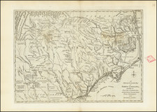
Rare map Swedish Edition of Melish's map of the Southern United States, from Klinckowstrom's Bref Om de Forenta Staterna Forfattade…
The map is based upon Melish's map of the same title, first issued in Melish's Military & Topographical Atlas, one of the most coveted of all 19th Century Atlases, published in 1813 and 1815 to illustrate the actions of the War of 1812. This southern sheet extends from the Chesapeake to Florida in the east and to Texas and the Kansas, Grand, Osage and Red Rivers in the west. Full of early Indian and Territorial information, plus roads, forts, distances, etc. The road from Natchitoches to the Spanish Presidio on the Trinity River in Texas is shown, as is the Spanish Cantonment farther downstream. Notes on the villages visited by Pike and a number of important early western settlements are also shown. Based upon early information contemporary to the War of 1812.
John Melish (1771-1822) was the most prominent American mapmaker of his generation, even though his cartographic career lasted only a decade. Melish was born in Scotland; he moved to the West Indies in 1798 and then to the United States in 1806. By 1811, he had settled in Philadelphia and published Travels through the United States of America, in the years 1806 & 1807, and 1809, 1810, & 1811, which was richly illustrated with maps.
Melish created several regional maps of the highest quality, as well as the Military & Topographical Atlas of the United States (Philadelphia, 1813, expanded 1815). The latter work is widely considered to be the finest cartographic publication to come out of the War of 1812.
By far his best-known work is his monumental map of the United States of 1816, Map of the United States with the contiguous British and Spanish Possessions. He began working on the map in 1815 and sent it to Thomas Jefferson for comment in 1816. Jefferson enthusiastically reviewed the map and returned it with his edits. Jefferson later hung an example of the map in the Entrance Hall of Monticello and sent it to associates in Europe.
Melish’s finished product was the first map of the United States to extend to the Pacific Ocean. After its publication in 1816, Melish ensured the map was as up-to-date as possible; it was reissued in 25 known states published between 1816 and 1823. The map captured the then rapidly changing geography of the United States, as well as various boundary disputes, treaties, and expansion.
![[ Virginia / Mouth of the Chesapeake Bay ] A Draught of Virginia from the Capes to York in York River and to Kuiquotan or Hamton in James River by Mark Tiddeman](https://storage.googleapis.com/raremaps/img/small/103814.jpg)