


|
||

|

|
|

|
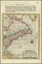
Nice example of this remarkable map of Canada, the Great Lakes and the Course of the Mississippi, extending south to the Missouri River.
This map is one of the best obtainable compilations of the location of the various French & Indian Churches, Forts and settlements during the period, and also depicts significant river crossing locations, portages and other essential travel information in the region. The search for the water route to the Pacific is still very much alive in the reports of this map, although no difinitive route is shown as clearly open.
Henri Abraham Chatelain (1684-1743) was a Huguenot pastor of Parisian origins. Chatelain proved a successful businessman, creating lucrative networks in London, The Hague, and then Amsterdam. He is most well known for the Atlas Historique, published in seven volumes between 1705 and 1720. This encyclopedic work was devoted to the history and genealogy of the continents, discussing such topics as geography, cosmography, topography, heraldry, and ethnography. Published thanks to a partnership between Henri, his father, Zacharie, and his younger brother, also Zacharie, the text was contributed to by Nicolas Gueudeville, a French geographer. The maps were by Henri, largely after the work of Guillaume Delisle, and they offered the general reader a window into the emerging world of the eighteenth century.
![Colton's Map of the United States The Canadas &c. Showing the Railroads, Canals, & Stage Roads With Distances From Place to Place…1856 [Pocket Map]](https://storage.googleapis.com/raremaps/img/small/85342.jpg)

