|
||

|

|
|

|
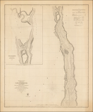
Rare and highly desireable chart of the Chesapeake and Delaware Rivers by Fielding Lucas.
Shows inland navigation on the rivers as far upstream as Philadelphia, Port Deposit, Baltimore, Washington, and for considerable distances up the Rappahannock, York and James Rivers. Soundings extend along the eastern shore into the lower Chester River, Eastern Bay, the mouth of the Choptank, and Tangier Sound. The entrances to both major bays depict the major shoals, and the bays on the Atlantic side of the peninsula are sketched in. There are four profile viewss of the shore, and tide tables for both bays.
Fielding Lucas, the only map and chart maker operating in Maryland at the time, first issued the chart in 1829. Morrison & Hansen note that it represented an innovated use of color, which was not employed by the US Coast Survey or its successors until the 20th Century. Morrison & Hanson note that three of the four views on the map derive from British Admiralty sources. The present example is backed on linen and was used as a working chart. It is a remarkable example, in clean and attractive condition, with only minor soiling and other faults. Lucas was one of the most celebrated early 19th Century map makers. His seperately issued maps are rare on the market.
Fielding Lucas, Jr. (1781-1854) was a prominent American cartographer, engraver, artist, and public figure during the first half of the 19th century.
Lucas was born in Fredericksburg, Virginia and moved to Philadelphia as a teenager, before settling in Baltimore. There he launched a successful cartographic career. Lucas's first atlas was announced in early- to mid-1812, with production taking place between September 1812 and December of 1813, by which point the engravings were complete. Bound copies of the atlas -- A new and elegant general atlas: Containing maps of each of the United States -- were available early in the next year, beating Carey to market by about two months. Lucas later published A General Atlas Containing Distinct Maps Of all the known Countries in the World in the early 1820s.