


|
||

|

|
|

|
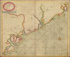
Fine old color example of this scarce map of the coast of South Carolina from the English Pilot, Fourth Book.
Nice example of the third state of this fine chart of South Carolina, updated by Mount & Page just after the conclusion of the French & Indian War. The map provides soundings and shows the settlements along the coast. It was originally drawn from Mathews manuscript map of 1685, with substantial additions. Extensive place names, rhumb lines, soundings, compass Rose, etc. Only two examples of the map have been offered in dealer catalogues in the past 25 years, both uncolored and in relatively poor condition, for relatively late states of the map. A fine dark impression and an excellent example of the map in old color, the first old color example we have seen on the market.

![[ The Marks of Sundry of the Chief Men of Virginia ] Aliquot Heroum Virginiae Notae.](https://storage.googleapis.com/raremaps/img/small/98859.jpg)