


|
||

|

|
|

|
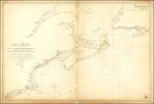
Rare first state of Hendrick Doncker's chart of the region from Narrangansett Bay and Cape Cod to Nova Scotia, Newfoundland and the Grand Banks.
Doncker's first state of the map pre-dates the engraving of the Grand Banks region, when the shape was changed and many new soundings added. The first state is very rare, with no examples having appeared in a dealer catalogue in the past 25 years and only two examples of the 1678 edition appearing during this time (Lan Catalogue 24--1998 and Arkway Catalogue 53--2000).
"Hendrick Doncker became one of the most active of the marine atlas and chart publishers in Amsterdam in the second half of the seventeenth century. He was the first to follow Arnold Colom with a comprehensive sea atlas" -- Burden. Based on the influential Van Loon chart, this map of the maritimes first appeared in Doncker's Zee-Atlas in 1669, and the Grand Banks were completely re-engraved with added soundings for this 1678 edition.
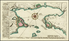
The map covers the region bounded by Hudson Bay, Baffin Bay, Greenland and the Northern part of Newfoundland. Includes several notes concerning the explorations of Button, Hudson and Thomas Jacobus. Includes several tentative coastlines and several hopeful passages to the Pacific Ocean.
The Jacobsz/Lootsman family began with father Anthonie Jacobsz, who along with Blaeu and Colom were the most famous sea chart makers in Holland in the first part of the 17th Century. After Anthonie's death in 1643, his sons Caspar (born 1635) and Jacob continued the business after a period where their mother kept the business going until the sons came of age. Once the sons took over, they quickly changed their names to Lootsman, to avoid confusion with the father. Certainly by 1666, Caspar would have been old enough to have already engraved this map, there fore it is possible that this map actually pre-dates the work of Van Loon and Goos. While most of the body of work produced by the Lootsman bothers came in the 1670s, they are credited with work in the 1660s as well.
Regardless of the issue of primacy of the map sequence, the map represents an extraordinary find, being one of the few maps attributed solely to Caspar Lootsman and apparently an unrecorded example, which was not noted by Philip Burden in either of his books. Lootsman's charts are very rare on the market.
Hendrik Doncker was a prominent bookseller in Amsterdam best known for his sea charts and nautical atlases. He issued his own original charts, which he updated frequently, and also worked with colleagues like Pieter Goos, for example to produce the pilot guide, De Zeespeigel. He died in 1699, after fifty years in business. His plates then passed to Johannes van Keulen.
![Partie du Cours du Fleuve de Saint Laurent depuis Quebec jusqu'au Cap aux Oyes [on sheet with] Carte du Cours du Fleuve Saint Laurent depuis Quebec jusqu'a la Mer en Deux Feuilles ... 1761](https://storage.googleapis.com/raremaps/img/small/55185.jpg)

![[The First Maps Printed Color] Cartes en Couleur des Lieux Sujets aux tremblements de Terre Dans toutes les parties du Monde Selon le Sisteme de l’impulsion Solaire](https://storage.googleapis.com/raremaps/img/small/52293op.jpg)