


|
||

|

|
|

|
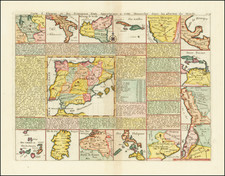
Terrific map of the Spanish Possessions throughout the world. At the center is a map of Spain, which is surrounded by maps of its various colonial possessions, including portions of Italy, Sicily, Sardinia, Cuba, Hispaniola and Puerto Rico, Nouveau Mexique (New Mexico & Texas), Texas, the Gulf of Mexico, Yucatan and South America, The Antilles and Terra Ferme, Peru, Chili, Argentina, Brazil, the Philippines, the Low Countries and the Canaries. In each instance, there is a text note on each of the maps. A flawless example in striking color.
Henri Abraham Chatelain (1684-1743) was a Huguenot pastor of Parisian origins. Chatelain proved a successful businessman, creating lucrative networks in London, The Hague, and then Amsterdam. He is most well known for the Atlas Historique, published in seven volumes between 1705 and 1720. This encyclopedic work was devoted to the history and genealogy of the continents, discussing such topics as geography, cosmography, topography, heraldry, and ethnography. Published thanks to a partnership between Henri, his father, Zacharie, and his younger brother, also Zacharie, the text was contributed to by Nicolas Gueudeville, a French geographer. The maps were by Henri, largely after the work of Guillaume Delisle, and they offered the general reader a window into the emerging world of the eighteenth century.
![(Italy and Austria) Carta geografica statistica postale dell’I.R. Monarchia Austriaca e dell’Italia [Statistical postal geographic map of the Imperial Royal Austrian Monarchy and of Italy]](https://storage.googleapis.com/raremaps/img/small/94038.jpg)
![[Majorca, Minorca, Ibiza] Carta Esferica de Las Yslas Baleares y Pithyusas, arreglada a la que se construyo en 1807 en la Direccion Hydrographica de Madrid. Publicala Dn. Jose de Espinosa Gefe de Esquadra de la Rl. Armada y primer Director de dicho Establecimiento Londres Año 1812.](https://storage.googleapis.com/raremaps/img/small/58779.jpg)