|
||

|

|
|

|
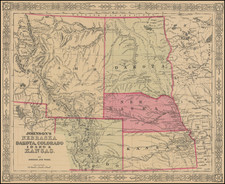
Remarkable large format map of Dakota Territory, prior to the split. One of the earliest large format separate maps of Dakota Territory. The map illustrates the early railroads, settlements, Mining Districts, Indian Reservations, Forts and other important early features.
Asher & Adams atlas was one of the first United States atlases to exclusively feature railroad lines, showing minimal topography (in this later edition more topographical features are added, earlier editions have fewer features shown ) and only showing towns on or next to the railroads lines.
Asher & Adams was a New York publishing firm known for their atlases. Notably, their maps were some of the first to prominently exhibit railroad lines, even if this meant a slight reduction in topographical detail. They specialized especially in state and county maps of the United States.
Asher & Adams was a New York publishing firm known for their atlases. Notably, their maps were some of the first to prominently exhibit railroad lines, even if this meant a slight reduction in topographical detail. They specialized especially in state and county maps of the United States.
![(Civil War) Fredericksburg … [with] Map… of the Sioux Expedition [with] Map of the Fight of the 14th A.C. Buzzard Roost, GA [and ] Big Mound [and] Dead Buffalo Lake [and] Dry Fort Creek](https://storage.googleapis.com/raremaps/img/small/97072.jpg)

![[First Map of the Mississippi River] Carte de la decouverte faite l'an dans l'Amerique Septentrionale](https://storage.googleapis.com/raremaps/img/small/93571.jpg)