|
||

|

|
|

|
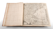
Unrecorded "last" edition of Tanner's separately issued map of the United States, with significant updates and additions from prior editions of the map.
Tanner's map of the United States was first engraved in 1829 with major revisions in 1843 as indicated by the copyright. This updated example is dated 1845 in the title. The map was engraved by Tanner with assistance from E.B. Dawson, W. Allen, and J. Knight. It shows the Independent Republic of Texas as "Part of Texas." Curiously, Victoria county is not named, but the short-lived judicial county of Spring Creek is shown. Locates counties and land grants. Names San Antonio, Colorado, Gonzales, Bastrop, La Feyette, Ft. Houston, Robertson, Red River, and Jasper to name a few.
The US-Canadian boundary extends to the Lake of the Woods, with an annotation noting the Treaty of 1818 and the significance of the 49th Parallel. In the Northeast the border settlement by the Convention of 1842 is shown, as is the earlier 1831 boundary as settled through arbitration by William I, King of Holland. Includes nice detail along the Missouri River, naming Fort Mandan and numerous Indian tribes, with their populations noted. The map also locates the routes and portages between lakes, the American Fur Co., and numerous trading posts.
The map is bounded at the sides with 14 large city plans and a chart of the "South Part of Florida." The plans include the cities of New Orleans, Charleston, Cincinnati, two of New York City, Boston, Albany, Baltimore, Philadelphia, Pittsburgh, and Washington D.C., which contains a floor plan of the Capitol building. Above the main map is a large inset "Oregon and Mandan Districts" that contains a small inset "Outlet of Oregon River" which names Astoria. The legend describes Important Towns, Small Towns & Villages, Canals, Rail Roads, and McAdamized Roads. Good detail of the National Road that was fully McAdamized between Cambridge, Ohio and Terra Haute, Indiana.
This remarkable late example of the map post dates the 1844 edition, which Ristow beleived to be the last printing of Tanner's grand large-scale map of the United States. "Tanner undertook the ambitious task of compiling a large map, the United States of America, which he copyrighted on June 10, 1829. It is at the scale of 1:2,000,000, somewhat larger than Melish's 1816 map of the United States. . . Tanner's United States of America has thirteen inset maps, principally of cities and their environs, a statistical table, and profiles of a number of canals and railroad rights of way…" Rumsey refers to the map as "one of best early large maps of the United States and the premier map for its period."
In December 2005, the Babinski copy of the map sold for $19,500 (Swann, Lot 83).
![[Whoever is silent is Complicit -- Anti-Vietnam / Anti-American Poster] Vietnam: Sterminio | chi tace è complice](https://storage.googleapis.com/raremaps/img/small/89365.jpg)

![United States History-Map (Five historical maps, including Toscanelli's Map of 1474) [Cover title:] Bacon's Excelsior Wall Atlases - America](https://storage.googleapis.com/raremaps/img/small/88839.jpg)