
The item illustrated and described below is sold, but we
have another example in stock. To view the example which
is currently being offered for sale, click the
"View Details" button below.


|
||

|

|
|

|
Stock# 18805
Description
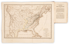
Marvelous late 18th Century map of the United States, East and West Florida and part of Canada.
The map shows Georgia extending to the Mississippi River, pre-dating Mississippi Territory. Massive Western Territory dominates the Old Northwest Territory, with no suggestion of Jefferson's propositions for the dividing the region. Kentucky is named, but without a defined northern border. Both East and West Florida are shown, pre-dating the first US incursions into the region. Many Indian Tribes named, along with some Western Forts and several annotations. Chicago named (Chickago).The map appeared in Cooke's Geography, published from about 1800 to 1817, apparently without changes to the map.

![The Travellers Guide or Map of The Roads, Canals & Rail Roads of the United States, With the distances from Place to Place By H.S. Tanner 1845 [with] The American Traveller, or Tourists' and Emigrants' Guide Through The United States . . . .](https://storage.googleapis.com/raremaps/img/small/99038.jpg)

