|
||

|

|
|

|
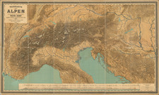
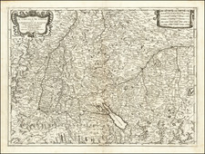
Scarce regional map of Europe, extending from the Po River Valley to the Gulf of Venice and from the Boden Zee and Saltzburg, centered on Lago di Garda.
The map provides a remarkably detailed topographical view of the region north of the Alpennines, including the thriving commercial and agricultural regions from Turin and Milan to the low lying regions west of Venice, with many postal roads and other details shown. The map includes an elaborate title cartouche reflecting the military activity in the mountainous regions of the map, including an image of a cannon and soldier being hoisted up a steep cliff, an allegorical representation of the battles being waged between the Habsburgs to the north and the various powerful Italian families to the south during the first half of the 18th Century.
Matthäus Seutter (1678-1757) was a prominent German mapmaker in the mid-eighteenth century. Initially apprenticed to a brewer, he trained as an engraver under Johann Baptist Homann in Nuremburg before setting up shop in his native Augsburg. In 1727 he was granted the title Imperial Geographer. His most famous work is Atlas Novus Sive Tabulae Geographicae, published in two volumes ca. 1730, although the majority of his maps are based on earlier work by other cartographers like the Homanns, Delisles, and de Fer.
Alternative spellings: Matthias Seutter, Mathaus Seutter, Matthaeus Seutter, Mattheus Seutter