|
||

|

|
|

|
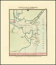
Extremely rare and important map of Charleston, being the first printed fire map of any city in the world and one of only 3 or 4 examples known to exist according to Walter Ristow (American Maps & Mapmakers 244-46).
The history of insurance maps began in London at the end of the 18th Century. Thomas Leverton is credited with having produced a map of central London for the Phoenix Assurance Company, Ltd., around 1785 but the Phoenix Company, which is still in business, has no record of such a map having been prepared. Between 1792 and 1799, Richard Horwood compiled for the Phoenix Company a map of London at the scale of 26 inches to a mile. This large-scale detailed map, which is on thirty-two sheets, identifies by street number every dwelling and commercial structure then standing. Horwood dedicated his map to the Trustees and Directors of the Phoenix Fire Office.
While the Horwood map of London is perhaps the most famous of all early fire insurance maps, the first fire insurance map ever produced is this extremely rare map of Charleston , published by the Phoenix Company in 1790 and prepared by the son of one of Charleston 's most famous colonial artisans.
During the period from around 1785 to about 1820, the Phoenix Company extended its insurance coverage to buildings in the West Indies, Canada , and the United States . The first map from these activities is this rare plan of Charleston , South Carolina , published in 1790 from a survey made in August 1788 by Edmund Petrie. Petrie's Ichonography of Charleston, South Carolina, At the Request of Adam Sunno, Esq. for the use of the Phoenix Fire- Company of London, Taken from Actual Survey, 2d August 1788 by Edmund Petrie. Published 1st Jany. 1790 by E. Petrie No. 13 America Square, is a landmark in the cartographic history of Charleston and as the earliest known fire insurance map of any city in the world. The plan, on a scale of 400 feet to an inch, identifies public buildings, churches, wharves, business establishments, streets, and public and private wells by numbers or letters and notes that there are "9 Fire Engines belonging to the City."
The Phoenix Company formed a committee in October 1786 to procure plans of towns abroad. The company records reference only a single plan acquired for any American city. In the minutes dated November 5, 1788, the committed resolved that One Hundred Guineas be paid for a plan of Charleston and that a Mr. Sunno be requested to transmit the same to the Person who executed the Plan. The plan was prepared in connection with the Phoenix Company's decision to issue a policy in August 1785 for the 'buildings of Mr. Poinsett, in Charles Town'. In connection with this policy, in August 1789, a fire engine, prepared with suitable inscriptions, was sent to Charleston , South Carolina , as a present to the Union Fire Club of Charleston. A second engine was sent in May 1802.
During the American Revolution, after the fall of Charleston , Edmund Petrie joined in the service of the British, but later claimed also to have as a counter-spy, feeding substantial intelligence reports to the American commanders in the region, as part of the spy ring organized by Colonel John Laurens. Edmund's death notice was published in The South Carolina Gazette on Wednesday, October 24, 1798.
It would seem probable that Mr. Poinsett was the father or Joel Poinsett, who was born in Charleston in 1779, educated in England , but would return America in 1788 and enjoy a distinguished career as an American Statesman, founder of the Academy of Fine Arts in Charleston and the person for whom the Poinsettia is named.
Ironically, Charleston is also credited with being home to the first fireproof building. Construction of Charleston 's Fireproof Building began in 1823 and was completed four years later. This building, which is located at 100 Meeting Street , was designed by Robert Mills. The same Robert Mills would go on to publish the first American County Atlas, the Atlas of the State of South Carolina , published in Baltimore by Fielding Lucas Jr. in 1825.
![[ Carolinas & Georgia ] Virginiae Partis australis, et Floridae partis orientalis, interjacentiumqus regionum Nova Descriptio](https://storage.googleapis.com/raremaps/img/small/81554.jpg)
![Carte Qui Contient La Maniere Dont Se Fait La Chasse Des Bouefs Sauvages . . . [Buffalo, Niagara Falls, Calumet Village, Huron & Illinois Indians]](https://storage.googleapis.com/raremaps/img/small/93146.jpg)
![Carte De La Louisiane Et Du Cours Du Mississipi . . . Juin 1718 [1st State!]](https://storage.googleapis.com/raremaps/img/small/59797.jpg)