|
||

|

|
|

|
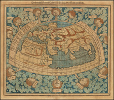
An excellent example of Paolo Forlani's third map of the world, which Forlani derived from Giacomo Gastaldi's 1546 prototype world map and Forlani's earlier world map of 1560. The present example is State 2 of the map, which bares the imprint of Forlani and Fernando Bertelli.
Between 1560 and 1570, Forlani issued four world maps, this version being the most majestic. As with Forlani's earlier world maps, this edition is a re-interpretation of Gastaldi, however a significant addition has been made: a large and extensive southern continent is shown and labeled "Terra Incognita". Forlani has populated the unknown southern land mass with imaginary topographical features as well as unlikely animals - among them a camel, an elephant, a lion, a rhinoceros and most outlandish, a griffin and a unicorn.
By 1565, Forlani's maps of northern North America included the label "Nueva Franza" to recognize the growing French role in exploring what was still a little-known continent. Despite Gastaldi pioneering the idea of separate Asian and American continents with the addition of the Strait of Anian in 1562, Forlani disregards this advance. North America is still shown joined to Asia, but many of the eastern coastal features compare well with modern maps; proof that Forlani was skilled at incorporating the latest knowledge about North America's shape from existing charts and explorers' descriptions. Florida and Cuba, for example, are quite accurately positioned.
Forlani's large world map was published in 1565, the year before Venice would reach what David Woodward calls the "zenith of map engraving". The map is highly decorative, featuring two cherubs in the top corners blowing the winds. In the lower corners are lines of text, including a dedication to Bartolomeo Zacco. Other embellishments include: numerous sea monsters, a nude figure riding a large sea creature, nine sailing vessels, and varied land animals. Forlani's fanciful style made him one of the most popular Italian cartographers of the 16th Century.
The significance of this Forlani map is indicated by its designation as "remarkable" in Frederick Muller's classic work on cartography, Remarkable Maps of the 15th, 16th and 17th Centuries (Amsterdam, 1897). A superb example of this cartographic landmark.
Paolo Forlani (fl. ca. 1560-1571) was a prolific map engraver based in Venice. All that is known of his life are his surviving maps and prints, of which there are almost 100 (185 with later states included in the total). He also produced a globe and two town books. It is likely he came from Verona and that he died in Venice in the mid-1570s, possibly of the plague.
![[Early Photographic Facsimile of the 1527 Weimar Spanish World Map]](https://storage.googleapis.com/raremaps/img/small/67281.jpg)
![[Wall Map of the World] Mappemonde Dressee et Grave Specialement pour Le Petit Journal D’apres les Documents le Plus Regents . . .](https://storage.googleapis.com/raremaps/img/small/70573rd.jpg)