|
||

|

|
|

|
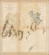
Fascinating early map from the fledgling US Forestry Agent.
This unommon map of the Intermountain West featuring forest lands,shown in green and main irrigation canals shown with red overprinting, was issued by the nascent Forestry Agent of the US Dept of Agriculture. The map stretches from Canada to Mexico and includes Idaho, Montana, Wyoming, Utah, Colorado and New Mexico with most of Arizona. Remarkable detail throughout including surveyed townships, towns, forts, Indian Reservations, and watershed plus topography by hachure. An important map documenting the canal and irrigation systems eventually created in the West.
The US Department of Agriculture was established as a Cabinet Level department by Abraham Lincoln in 1862. In 1876, Congress created a Special Agent in the Deptartment of Agriculture to assesss the state of the forests in the United States. Franklin B. Hough was appointed to head the office, which was expanded in 1881 go become the Division of Forestry.
These early forestry maps are quite rare on the market.

![Mexico [Texas on the Eve of Independence]](https://storage.googleapis.com/raremaps/img/small/84917.jpg)