|
||

|

|
|

|
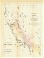
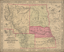
Second issue of Fremont's seminal map of the West. The second edition is a full scale copy of the the first edition, but focuses primarily on California, Arizona, Nevada and Utah.
Wheat dedicates 13 pages and 2 illustrations to this map, which more than any other map before or after its publication embodied the changing American West. Fremont travelled to California in 1845, making new and important explorations enroute, especially in the Great Basin. He proceeded north to Klamath Lake and was then summoned back to Monterey to participate in the conquest of California.
John C. Fremont (1813-1890) was born in Savannah, Georgia. Fremont married Jessie Benton, the daughter of Senator Thomas Hart Benton, who would go on to promote Fremont's career very actively. Benton, a fervent believer in Manifest Destiny, obtained Congressional fudning for three surveys of the West which would be led by Fremont, the Oregon Trail in 1842, Oregon Territory in 1844 and the region between the Great Basin and the Sierras in 1845. Fremont would go on to be appointed the first military Governor of California, but was later arrested and found guilty of mutiny.
Wheat notes that Fremont's map and the accompanying text had "a two-fold importance in history, first as contributions to geographical and cartographical knowledged in the year 1848 and second as historical documents concerning Fremont's notable Third Expedition." Unlike the maps issued in connection with the First and Second Expeditions, this map shows the entirety of the regions explored, synthesizing all available information, not just the information derived from the expedition. The map includes Wilkes information in Oregon and Emory's information to the southeast. For California, Fremont relied mostly upon his own observations. Interestingly, the map also perpetuates errors which date back to errors made by Vancouver. Among the more interesting contributions to the map are those likely provided by legendary fur trapper Old Bill Williams, who joined the expedition for several weeks. Williams, who by then was in his 60s, counted among his friends and peers Zebulon Pike.
The importance of the map to the history of the mapping of the West cannot be understated. It is unquestionably one of the most important American maps of the 19th Century and a cornerstone to any Western collection.