|
||

|

|
|

|
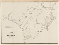
Important original manuscript survey of a large part of the modern city of St. Louis, Missouri by Joseph C. Brown, covering approximately 9000 acres on the Mississippi River. The survey covers the area originally surveyed by Antoine Soulard for the Spanish Governor of Louisiana. Brown's survey is the earliest surviving US Survey of the area and the subject matter of many important land ownership cases decided by the United States Supreme Court in the second half of the 19th Century.
Formal land ownership records and documentation for the St. Louis areas date back to the Spanish grants by Don Zenon Trudeau, Lieutenant-Governor of Upper Louisiana in the 1780s. The area was more formally surveyed between 1796 and 1800 by Antoine Soulard, then serving as Surveyor-General of the Province of Upper Louisiana. Soulard conducted his surveys immediately after mapping the area between the Mississippi and Missouri Rivers in 1795.
The first US Survey of the region was conducted by Elias Rector, whose father William Rector was the Territorial Surveyor for Illinois and Missouri. Unfortunately, the original survey did not survive and only the field notes were retained by the Land Office in St. Louis. In 1834, Elias T. Langham, US Surveyor General at St. Louis, instructed his deputy Joseph C. Brown to re-survey and re-trace the lines of the 1815 Rector Survey.
The Brown survey apparently conflicted with a prior survey and beginning in the late 1830s, a dispute arose between the Cities of St. Louis and Carondolet over the ownership of the northern portion of lands surveyed by Soulard, Rector and Brown, including land granted to the US Government in 1829 which would become Jefferson Barracks (see map). As noted by the US Supreme Court in Carondelet v. St. Louis, 66 US 1 (1861):
The Act of Congress of June 13, 1812, confirmed to the inhabitants of certain towns and villages (among others, Saint Louis and Carondelet) "the rights, titles, and claims to town or village lots, out-lots, common-field lots, and commons in, adjoining or belonging" to them, which were "inhabited, cultivated, or possessed" prior to December 20, 1803, "according to their several right or rights in common thereto." . . . In 1816, Congress provided for a survey of all claims confirmed by previous acts. . . .
Saint Louis was incorporated in 1809, and Carondelet in 1832. . . The limits of Saint Louis were described as extending southward to Sugar Loaf Mound. The bounds given to Carondelet extended 2,640 yards on the Mississippi and west to Fourth Street, but did not include the north common, or the fields, or the south commons [then claimed by Carondelet].
In 1816, or 1817, a survey was made by Elias Rector, a deputy surveyor. . . In 1834, Joseph C. Brown . . . retraced and marked the survey of Rector. Brown's work was approved by the Surveyor General. His survey ascertained and marked all the lines of the common land appurtenant to Carondelet, and found its contents to be 9,905 acres, or about 11,642 arpents. The authorities of Carondelet were present at the making of this survey by agents specially appointed for that purpose. They procured a copy of it and directed it to be framed for the benefit of the town. In 1839, they ordered all the commons north of the River des Peres to be leased. . . In several suits between
the town and other parties, Carondelet gave Brown's survey in evidence as the basis of her title. When an attempt was made in the War Department of the United States to annul the survey, Carondelet protested and petitioned Congress to confirm their right according to the survey. The City of Saint Louis in the meantime (1836) proceeded to subdivide her common lands into lots down to the line of Brown's survey and sold them, but not without a formal notice from a committee appointed by Carondelet that the lands were claimed by the latter corporation. This suit was brought in 1855 [to finally resolve this dispute]. . . .
The map offered here is an early official copy of the Brown's survey (dated July 29, 1834), and includes original annotations referencing the use of the prior field notes of Elias Rector and other previously confirmed grants to Gabriel Conetant and Julien Choquette. The original Brown survey bears a date of March 17, 1834. Joseph C. Brown was among the most important early American field surveyors. Beginning in 1805, Brown served as the principal surveyor of the 5th Principal Meridian west of the Mississippi River in Louisiana Territory. Brown would go on to serve as the principal field surveyor for a number of the US Government's major surveys west of the Mississippi River. He was without question one of the major surveyors of the lands acquired in the Louisiana Purchase.
Carondelet's history dates to about 1702, when Catholic missionaries visited the Indians at the mouth of the River des Peres ("River of the Fathers"). In 1767, Clement DeLore de Treget established the first permanent settlement. DeLore was vested with authority to govern the colony by the Spanish, who had acquired Louisiana Territory by treaty from the French in 1762. He laid out long strips of land for cultivation in the Carondelet Commonfields (see map). South of this farming area DeLore laid out a large Commons of pasture land for grazing of livestock. This area was bisected by the River des Peres and became known as the Carondelet Commons. At first called DeLore's Village, the town underwent several name changes such as Louisburg, Prairie a Catalan and finally, in 1794, Carondelet in honor of Baron Francois Louis Hector de Carondelet, the Spanish governor of Louisiana. Carondelet would remain a community until it was annexed by St. Louis in 1870.
On July 8, 1826 1,702 acres of the Commons of Carondelet were sold to the US government for $5.00. Initally called Cantonment Adams in honor of then president John Qunicy Adams, it would become Jefferson Barracks. By 1829, 500 troops were stationed at Jefferson Barracks and the first permanent buildings completed in 1837.
Joseph C. Brown (died 1849) was a surveyor for United States General Land Office who during his professional career performed several of major surveys in the Louisiana Territory.
Among his notable surveys were the following:
1. Initial point of the 5th Principal Meridian (1815) - Brown established the initial point of the 5th Principal Meridian which was to be used for surveying lands in the Louisiana Purchase in the states of Arkansas, Missouri, Iowa, Minnesota, South Dakota and North Dakota. Brown established the baseline on October 27, 1815 at the mouth of the Mississippi River. Prospect Robbins surveyed north from the mouth of the Arkansas River on the Mississippi. Where the two lines met was the Initial Point which is in Louisiana Purchase State Park in Arkansas.
2. First plat of St. Louis, Missouri (1815-1818) - Brown's starting point in the survey was the home of Auguste Chouteau.
3. Indiana Territory Line between Missouri and Indian Territory (1823) - Brown surveyed the line south from its origin at the confluence of the Kansas River and Missouri River and then surveyed the Missouri-Arkansas line. Virtually all Native Americans south of the Iowa line were to be moved west of line.
4. Santa Fe Trail (1825)
5. Commons of Carondelet (1834)--Brown was retained to re-survey the lands first surveyed by Soulard (1797) and Henri Rector (1818) (only the field notes survived). Elias T. Langham, surveyor general at St. Louis, ordered Brown to re-trace and re-establish the lines of Rector's survey, and when the result of the work was returned to his office, he approved the survey and the same was duly filed in the office of recorder of land titles in Missouri, who thereupon certified that the title was by him duly confirmed of the village of Corondelet to their claim as commons of six thousand arpents of land, as shown by that survey. There is no evidence that this survey was ever brought to the attention of the Land Department in Washington until June, 1839, and the survey was the subject matter of a number of US Supreme Court Cases over the remainder of the 19th Century.
6. Honey War line (1836)-- Brown's most controversial survey was the re-survey of the Sullivan Line, which caused Missouri to claim its border extended 13 miles into Iowa. When Missouri tax collectors attempted to collect revenue from the new territory they were run out of the state. In the process they cut down three trees with honey bee hives for partial payment. The source of the debate was the definition of the Des Moines Rapids. When Missouri entered the Union in 1820 it said its border extended from the rapids on the River Des Moines. Brown couldn't find the rapids at the said intersection with the river-and hence-said the rapids were further north. The Supreme Court was to repudiate what was called "Brown's Line" and uphold the Sullivan Line as the border (although resurveyed).

![[Rare First State] Novissima Tabula Regionis Ludovicianae Gallice dictae la Louisiane . . .](https://storage.googleapis.com/raremaps/img/small/72622.jpg)