This item has been sold, but you can enter your email address to be notified if another example becomes available.


|
||

|

|
|

|
Stock# 18168
Description
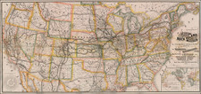
Rare "election map," lithographed by Britton & Rey in San Francisco and published following the election of Rutherford B. Hayes as the 23rd President of the United States.
The "map" includes 23 maps of the United States, depicting the territorial and state configuration of the United States at the time of the election of each President, along with a portrait of each President. The map also shows the election results by state keyed to the political party that carried it, (i.e. Republican, Whig or Democratic), with notes on running mates and other related data. A fascinating bit of Americana. Only one appearance in a dealer catalogue between 1982 and 2008 and no auction records. OCLC locates two examples.
Condition Description
Linen backed. Folds into brown leather covers, with decorative gilt title on frontice. A few minor tears, but generally a gorgeous example.
Reference
Phillips (Maps) p.929.