This item has been sold, but you can enter your email address to be notified if another example becomes available.


|
||

|

|
|

|
Stock# 18136
Description
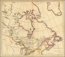
Scarce chart showing the region between Cape Grenville and Cape Suckling, including Whitsuntide Bay, Cape Whitsunday, Smokey Bay, Cape Douglas, Mount St. Augustine, Volcano Mountain, R. Turn-again, Cook's River, Point Possession, Anchor Point, Point Beale Cape Elizabeth Montagu Isle, Prince William Sound, Snug Corner Bay, Comptrollers Bay and Cape Hinchingbrook.
Includes Cook's tracks through the area, with dates and astronomical observations. Nice detail of the soundings, anchorages and the topography of the region.
Condition Description
Minor abrasion in upper right margin
![[ Alaska / Cabo San Lucas / San Blas / Chile ] Views of Headlands and Islands on the Coasts of North West and South America](https://storage.googleapis.com/raremaps/img/small/88077.jpg)