This item has been sold, but you can enter your email address to be notified if another example becomes available.


|
||

|

|
|

|
Stock# 17889
Description
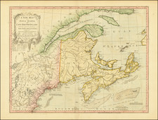
Detailed map covering the region from the New York City area and Long Island to the St. Lawrence River, including much of Northeastern part of Canada.
While the map is in the style of a sea chart with rhumb lines and delivers significant information concerning the coastal details of the regions covered, it also includes signficant information in the interior parts of the map. Prepared at the beginning of the American Revolution, Sartine's maps, along with he maps of Georges Louis Le Rouge, were the primary sea charts and maps carried to America by the French military, under the command of Rochambeau, which was instrumental supporting the efforts of the American colonists to secure their independence from England.
![[Anchorage, Valdez and Prince William Sound] Cote Nord-Ouest De L'Amerique Reconnue par le Cape. Vancouver VIe. Partie . . .](https://storage.googleapis.com/raremaps/img/small/92676.jpg)

![[ Missionary Map ] Canada Carte Indiquant Les Limites Des Dioceses, etc. Catholiques Romains Par G. Baillairge Ex-depute-ministre des Treavaux Publics de Canada 1893.](https://storage.googleapis.com/raremaps/img/small/37899.jpg)