This item has been sold, but you can enter your email address to be notified if another example becomes available.


|
||

|

|
|

|
Stock# 17847b
Description
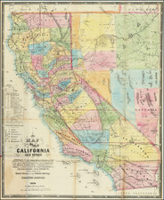
Scarce map of Utah, Colorado, Arizona and New Mexico, hand colored by counties. Very early edition, pre-dating the addition of Colorado the title.
Includes substantial details in each of these then territories of the US, including towns, mountains, rivers, Forts, Indian Villages, early railroads and proposed railroad routes, and many many other details. From HH Lloyd's scarce Atlas of the US, which only appeared as a supplement to Beers County Atlases in the early 1870s.
![[ US-Mexico Border Survey: General Order From the President of the United States Directing William H. Emory to lead the US-Mexico Boundary Survey ]](https://storage.googleapis.com/raremaps/img/small/101837.jpg)

![Mexique par Th. Duvotenay…1842 [Republic of Texas]](https://storage.googleapis.com/raremaps/img/small/93713.jpg)