|
||

|

|
|

|
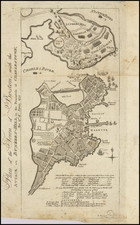
Detailed plan of Boston from Cyprian Southack's rare sea chart of New England.
Cyprian Southack was a commercial sea captain who sailed vessels in New England waters for 22 years. His New England Coasting Pilot (Boston, 1729-33) was on of the earliest compilations of coastal information for the region and provided the information obtained by Southack during his maritime career. Southack's work included eight charts of the region from the Hudson River to Nova Scotia. Although the accuracy of Southack's charts was widely criticized in the colonies, his work was adopted by London chartmakers. The present plan of Boston first appeared on Southack's A Map of the Coast of NEW ENGLAND, from Staten Island to the Island of Breton in 1744, as a compilation of the eight charts from Southack's atlas and was frequently reissued between 1775 and 1794 in Mount & Page's English Pilot, The Fourth Book. The plan is reminiscent of John Bonner's map of Boston, which may well be the source.
The Southack map of New England appears infrequently on the market, making this a nice opportunity to obtain this pre-Revolutionary War plan of Boston.