


|
||

|

|
|

|
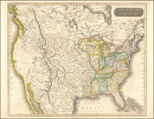
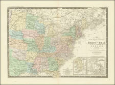
Very rare late edition of Thomson's map of the United States. Beginning around 1820, Thomson expanded his map of the United States to include the region west of the Mississippi River, extending to the Pacific Ocean. The detail in the Transmississippi West is truly outstanding, including the details of Lewis & Clark's expedition, Pike and Long's explorations to the Rocky Mountains and information from other western explorers. Several of the routes through the Rocky Mountains are shown, as is excellent detail in Texas and the Missouri Valley regions. The first time we have ever seen an edition of Thomson's map issued after 1830, with additions.
John Thomson (1777-ca. 1840) was a commercial map publisher active in Edinburgh. He specialized in guide books and atlases and is primarily known for his Atlas of Scotland (1832) and the New General Atlas, first published in 1817 and reissued for the next quarter century. The New General Atlas was a commercial success—it was also published in Dublin and London—and it compiled existing geographic knowledge in compelling ways for a wide audience.
His Atlas of Scotland introduced new geographic information and was the first large-scale atlas of Scotland to be organized by county. It provided the most-accurate view of Scotland available before the Clearances. Work on the atlas began in 1820 and led to Thomson’s bankruptcy in 1830 due to the high costs of gathering the latest surveys and reviewing the required materials. Despite the publication of the atlas, Thomson declared bankruptcy again in 1835.

![[Anchorage, Valdez and Prince William Sound] Cote Nord-Ouest De L'Amerique Reconnue par le Cape. Vancouver VIe. Partie . . .](https://storage.googleapis.com/raremaps/img/small/92676.jpg)