


|
||

|

|
|

|
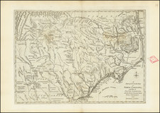
An extremely rare separately-issued Revolutionary War battle plan, by Robert Sayer, which appeared in Sayer's rare North American Pilot, depicting the British Siege of Charleston Harbor in June 1776 and the decisive battle fought at Fort Sullivan on June 28, 1776.
Sayer's plan of Charleston Harbor is one of the finest and rarest of all Revolutionary War Plans of Charleston, illustrating in great detail the British naval activity in the Harbor and the ultimate British attack and American defense of Fort Sullivan. Unlike smaller plans by Faden and Sayer & Bennett which illustrate only the Attack on Fort Sullivan, this plan provides a detailed account of the British movements throughout the entire Harbor and captures significantly more battle information. A similar plan of all of Charleston Harbor was issued by William Faden in his virtually unobtainable Atlas of the American Revolution.
In the Spring of 1776, South Carolina had been seized by the Americans. The British sent a fleet of twenty ships under Sir Peter Parker and Sir Henry Clinton to oust the Americans. The ships stopped at Five Fathom Hole and later landed on Long Island, just north of Sullivan's Island.
The Americans, under the command of William Moultrie, were woefully short of experienced troops and ammunition. Fort Sullivan was a rather primitive and indefensible structure hastily constructed by the Americans and not capable of withstanding any significant assault. Instead of attacking straight away, Clinton looked for a crossing between Long Island and Sullivan's Island, which did not exist. This gave the Americans, under the command of William Thomson, time to strengthen their positions.
On June 28th, the British attacked the fort, initially receiving heavy resistance, and were unable to sail close enough to the island to mount an effective offensive. The British lost two ships in the assault. The British attempt to storm Thomson's position was also defeated.
Robert Laurie (ca. 1755-1836) and James Whittle (1757-1818) formed their Fleet Street, London-based firm upon the 1794 death of their employer Robert Sayer, himself one of the dominant print and mapmakers of the last half of the 18th century.
Laurie & Whittle started managing Sayer's business as early as 1787. They took over all managerial duties when Sayer's health flagged in 1792, and they changed the imprint in 1794 upon his death. Sayer left the two a 21-year lease on the shop (at £100 a year) and on Sayer's Bolt Court premises, as well as an option to acquire stock and equipment at a preferential price of £5,000 payable over three years.
Robert Laurie retired from the firm in 1812, and his role was assumed by his son, Richard Holmes Laurie (1777-1858). The younger Laurie worked with James Whittle until the latter died in 1818. After R. H. Laurie died in 1858, Alexander George Findlay, FRGS (1812-1875) purchased the firm from his daughters. The firm continues today under another name, specializing in yachting charts.
Laurie & Whittle were prolific print and map publishers, and throughout their careers, they produced numerous very important and rare works. They carried on Robert Sayer's atlas business and were responsible for editions of The Complete East-India Pilot and The American Atlas.
![[ Cape Hatteras to New York City ] The Coast of the United States of North America; from New York to St. Augustine: Drawn and regulated according to the latest Surveys and Astronomical Observations By Edmund Blunt. Additions to 1839 & 1840](https://storage.googleapis.com/raremaps/img/small/84684.jpg)


![[ The Marks of Sundry of the Chief Men of Virginia ] Aliquot Heroum Virginiae Notae.](https://storage.googleapis.com/raremaps/img/small/98859.jpg)