


|
||

|

|
|

|
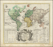
Scarce map of the World on Mercator's Projection made for the Prussian Royal Academy of Sciences. The map is quite detailed and includes two large tables of explanation. In North America the Northwest coast is blank and a river provides passage between the Great Lakes and the Pacific. Australia and New Zealand are depicted with partially completed coastlines. A large title cartouche decorates the map and the privilege stamp of the Academy appears above the table on the left.
Leonhard Euler (1707 -1783) achieved his greatest fame as a physician and mathematician. Among his other noteworthy achievements was the publication the Atlas Geographicus'for the Prussian Royal Academy of Sciences and Litterature in Berlin between 1753 and 1760. The atlas is one of the few 18th Century Atlases published in Berlin and is noteworthy for the outstanding up to date cartographical information inlcuded in most of the maps. Small printed original Prussian tax/privilege seal as always.
![Western Hemisphere [and] Eastern Hemisphere](https://storage.googleapis.com/raremaps/img/small/77454.jpg)
![Earth Atlantic View [Waterman Projection]](https://storage.googleapis.com/raremaps/img/small/86011.jpg)